Saturday, August 28, 2010

San Luis Peak

Dates of Trip: 28 August 2010
Climbers: hobo and tortoise
Location: San Juan Range, CO, USA
Trailhead: West Willow Creek
Summit Objectives: San Luis
Summits: San Luis Peak at 14019 ft
Starting Ele:  11500 ft
Ele. Gain:  ~3700ft
Distance:  11 mi

We drove out to the old mining town of Creede after work on Friday - a gorgeous drive.  We drove up the box canyon just north of Creede in the dark, the old mine ruins looming in the shadows.  We camped at what we thought was the trailhead and had a very pleasant night.

In the morning we discovered we were about a half mile from the trailhead, so we followed the other 14er baggers (not *too* many, as this is a non-standard route) to the trailhead at the end of the road and got on the trail.

This is a long-ish hike, as many in the San Juans are, but gentle and very scenic, cresting two passes before the summit push and contouring around their valleys.  There is a very disappointing section of significant elevation loss after the first mile or so, but other than that, it's very satisfying.

We made good time to the summit and spent about 20 minutes there, eating lunch and chatting with other hikers, and then rather suddenly, the sky started to cloud up and the temperature dropped.  There were still people on their way up, but we took the opportunity to drop down, quickly.  We got a few spatters of rain, but nothing too serious.  Still, we were in a hurry to get to a safer elevation and more protected area.

I got rather fatigued toward the end (which I'm blaming on being 5 weeks pregnant), which made the push back up that segment about a mile from the trailhead quite a slog, but I made it.  It was a really fun hike.

We ate dinner at a hippy burger joint in Creede before driving home that evening.


Saturday, August 21, 2010

El Yunque

Dates of Trip: 21 August 2010
Climbers: hobo and tortoise
Location: Sierra de Luquillo Range, El Yunque National Forest, Puerto Rico
Trailhead: Bano de Oro
Summit Objectives: El Yunque Peak
Summits: El Yunque Peak at 3496 ft
Starting Ele:  2100 ft
Ele. Gain: 1400 ft
Distance:  5.2 mile

We were in Puerto Rico for a quick weekend mileage run/first wedding anniversary celebration, and were looking for something active to do.  On our honeymoon, we had been into the El Yunque Rainforest, but due to time constraints, we didn't really see too much.  We took the opportunity for a short, laid back climb.  It turned out to be not too hot, and the humidity was a welcome change from our usual dry Colorado-ness.


We hiked El Yunque the day we found our we were pregnant with Bug.

Sunday, August 15, 2010

Father Dyer, Crystal, and Peak 10

Dates of Trip: 15 August 2010
Climbers: hobo, tortoise, and Jimmy
Location: Tenmile Range, CO, USA
Trailhead: Spruce Creek/Wheeler Trail
Summit Objectives: Father Dyer, Crystal, and Peak 10
Summits: Father Dyer Peak at 13615 ft, Crystal Peak at 13852 ft, Peak 10 at 13633 ft
Starting Ele:  11080 ft
Ele. Gain:  ~4000ft
Distance:  ~10 mile

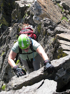
I have a little bit of Class III experience from the past - mostly moves here and there, and a knife edge ridge with some exposure on Katadhin.  We have some more challenging Class III routes on the list, and therefore we went searching for an intermediate Class III experience.  We found it on Father Dyer's East Ridge.  Jimmy, a colleague of hobo's, came along.

We met up in Idaho Springs and got to the Spruce Creek Trailhead at around 7am, for a nice early start.  This is the same trailhead as the one for Mt. Helen, and in fact, to get to Father Dyer, you hike around the base of Mt. Helen.  But mercifully this time, the road was not blocked by a large pile of snow (it being August and all), and we were able to drive all the way up to the gate at Aqueduct Road.  We followed the Wheeler Trail around the base of Mt. Helen and into the basin surrounded by Father Dyer, Crystal, and Peak 10, our objectives for the day.

We left the road and began ascending a steep, but mostly grassy knoll that sits below the east ridge of Father Dyer.  Up to the left we could see the "Dyer Straits" ridge (so punny) that connects Helen to Father Dyer.  It did look pretty gnarly.  The East Ridge loomed in front of us, and after a quick break for some fuel, we started up, first Class II, then some Class II+, then finally the Class III jungle gym of rock.  Words cannot possibly express to you how much fun this ridge was to climb.  This was very possibly the most fun I've ever had on a mountain.  I love to climb on rocks!  I'm not afraid of heights, and I don't mind some exposure - there was just enough to give you butterflies in the stomach.  But what I really can't abide is loose rock.  I want to know that the rock I'm using for a handhold or foothold is going to stay put.  And this rock was *solid*.  Very solid, lots of great, deep handholds, plenty of cracks and ledges for footholds.  I was a kid in a candy store.  Observe:


We reached the top of the ridge too soon (it seemed), and made the summit after a short stroll across the talus at the top.  The weather was phenomenally gorgeous, so we lingered to eat another snack, while several begging pikas looked on, hungrily. 


We struck out, then, for Crystal Mountain - the only "real" mountain of the day, rising more than 300 ft from its saddles with both Father Dyer and Crystal.  (The editor would like to point out that this doesn't even matter because Crystal is the tallest one around, so it wins by default.)  It was tedious and sort of annoying work to navigate down and then back up on the blocky talus, especially in the shadow of such a thrilling beginning to the day.  This is funny because I think any other time it would have just been a great day on the mountain.  The other thing was that I had been nursing a moderately severe cough for a few weeks. Somewhere around the ascent up the summit block of Crystal, my lungs started to get really upset at me and I was having some trouble breathing well.  Still, I took my time, and before too long, I made it up to the top of Crystal, with spectacular views of Mohawk Basin, Pacific, Atlantic, and Quandary, complete with toothpick 14er-baggers on top.


We descended to the saddle between Crystal and Peak 10 and reassessed the lung situation before making the call to go ahead and make it a three-peak day.  Since the weather was spectacularly nice - not a cloud in the sky - I felt that we should take advantage and at least make a go of it.  We had "all the time in the world," so I could take my time, which I did.  When I arrived on the summit of Peak 10, I found Jimmy taking a nap.


We had visions of a wide grassy shoulder rolling down to the Wheeler Trail, which we would then pick up and loop back around to the road and our car.  It was *almost* this way.  Except for this one massive downhill section of small scree and rubble.  If there's one thing I dislike more than loose scree and rubble it's *downhill* loose scree and rubble.  And this on tired legs.  We made it down though, and willed our tired aching legs and feet back to the car.  My lungs were wheezy and full of fluid, and Jimmy ended up with a migraine, but it was hard to put a damper on such a great day in the mountains.


I was pregnant with Andrew, but I didn't know it yet.