Showing posts with label car camp. Show all posts

Saturday, September 24, 2011

Spearhead Mountain


Dates of Trip: 24 September 2011
Climbers: hobo, tortoise, and bug (<5 months old)
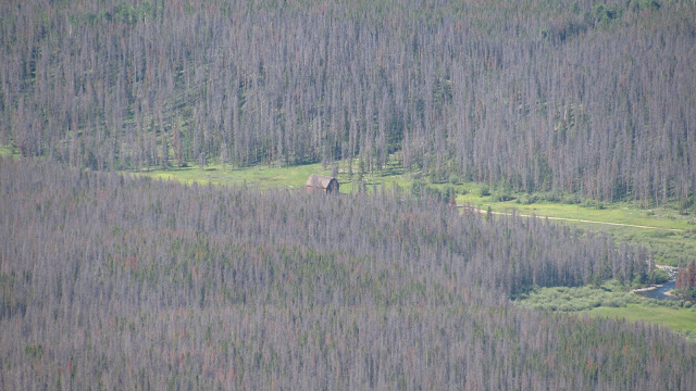
Location: Mt. Evans Wilderness, Pine National Forest, CO, USA
Trailhead: Threemile Creek
Summit Objectives: Spearhead
Summits: Spearhead Mountain at 11244 ft
Starting Ele:  8960 ft
Ele. Gain:  ~2300ft
Distance:  6.75 mi

Aaaaaaaand, we're back!  After a beautiful pregnancy, a wonderful birth, and some recovery time, we are back in the hiking/climbing saddle with a third climber(-to-be) in tow.

Bug had done 2 nights of camping prior to this one, but we still hadn't been successful at getting the gumption for a hike afterward.  We took advantage of the fact that it is now fall, kids are back in school, and therefore the close-in dispersed camping is much easier to come by.  We camped at an established dispersed campsite along Guanella Pass Road on the banks of Geneva Creek.

Camp next to Geneva Creek

Hobo cookin', Bug rollin'

Bug put himself to sleep by hanging onto the zipper pull on the tent door.

Happy camping family

It's Cold!
In the morning we proceeded to the Threemile Creek trailhead early.  It was pretty chilly, and Bug was bundled up.  We did a long sleeved onesie as base layer, then a fleece sleeper, thick socks over that, cotton newborn mittens (need to get some fleece ones!) and his fleece hat with the earflaps.  Then we draped a fleece blanket over him once he was in the carrier.  It was his first outing in the Deuter frame backpack carrier, and he did great!  He fell asleep a couple times and fussed when he was hungry, but mostly he seemed to enjoy the scenery.  


The fall colors were in full splendor - we walked through several groves of glowing golden aspens.


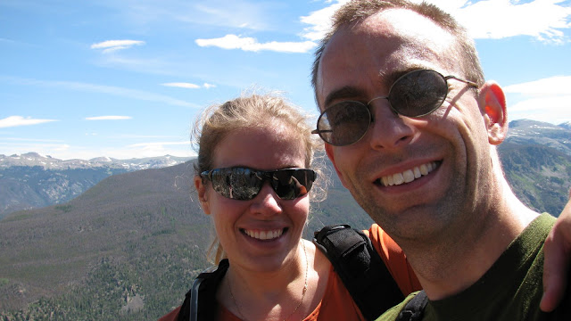
Once we reached the base of Spearhead's summit cone, we determined (as expected) that the final push was a little too steep and bushwhack-y to bring the baby up.  So Hobo ran up to the summit while I waited with bug around 10800 and ate lunch.  I was contemplating saying that the hike had been enough for me, I didn't need the summit, when Hobo came back and declared "best summit register ever!!!" and told me I HAD to go.  So Bug stayed with daddy while I made my summit push.  I was very slow, but I made it and indeed it was worth it.

Waiting for daddy.

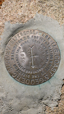
First of all, the summit register was in an old food jar of some kind.  The register itself was a small pocket notebook labelled "Woolworth's. 19c."  Classic!  The first page showed it had been placed in 1976.  There were very few entries (maybe 15 or so?) between then and now.  


Then, on page 3, appeared the name of Gerry Roach.  As in THE Gerry Roach - authority on all things Colorado Mountaineering, author of some of our favorite books, 12th American to summit Mt. Everest, 2nd person to complete the seven summits (highest peak on every continent), international mountaineering icon... Gerry Roach.  His summit log was dated October 8, 1983... just a few short months after he summitted Everest.  A-MAZING.  We have signed the same summit register as Gerry Roach.


It was just a beautiful day and a really fun hike.  It was "only" an 11er, but it was a challenge (I was SO sore the next day), and it was really great to stand on top of something again.


Saturday, August 28, 2010

San Luis Peak

Dates of Trip: 28 August 2010
Climbers: hobo and tortoise
Location: San Juan Range, CO, USA
Trailhead: West Willow Creek
Summit Objectives: San Luis
Summits: San Luis Peak at 14019 ft
Starting Ele:  11500 ft
Ele. Gain:  ~3700ft
Distance:  11 mi

We drove out to the old mining town of Creede after work on Friday - a gorgeous drive.  We drove up the box canyon just north of Creede in the dark, the old mine ruins looming in the shadows.  We camped at what we thought was the trailhead and had a very pleasant night.

In the morning we discovered we were about a half mile from the trailhead, so we followed the other 14er baggers (not *too* many, as this is a non-standard route) to the trailhead at the end of the road and got on the trail.

This is a long-ish hike, as many in the San Juans are, but gentle and very scenic, cresting two passes before the summit push and contouring around their valleys.  There is a very disappointing section of significant elevation loss after the first mile or so, but other than that, it's very satisfying.

We made good time to the summit and spent about 20 minutes there, eating lunch and chatting with other hikers, and then rather suddenly, the sky started to cloud up and the temperature dropped.  There were still people on their way up, but we took the opportunity to drop down, quickly.  We got a few spatters of rain, but nothing too serious.  Still, we were in a hurry to get to a safer elevation and more protected area.

I got rather fatigued toward the end (which I'm blaming on being 5 weeks pregnant), which made the push back up that segment about a mile from the trailhead quite a slog, but I made it.  It was a really fun hike.

We ate dinner at a hippy burger joint in Creede before driving home that evening.


Sunday, June 20, 2010

Mt. Sheridan and Peerless Mountain

Dates of Trip: 19-20 June 2010
Climbers: hobo and tortoise
Location: Mosquito Range, CO, USA
Trailhead: Horseshoe Basin
Summit Objectives: Horseshoe Mtn, with options on Sheridan, Peerless, and Finnback Knob
Summits: Mt. Sheridan at 13748 ft, Peerless Mountain at 13348 ft
Starting Ele: ~12000 ft
Ele. Gain: ~2500 ft
Distance: ~4.0 mile

We originally set out to ascend the Boudoir Couloir on Horseshoe Mtn in a "moderate" snow climb. This was one of the last weekends that it was expected to be available, as the snow would likely be melting out for the summer. Indeed, when we got into Horseshoe Basin, snow in the couloir was a very thin line, the temperature was warm, and as this was our first climb in quite sometime, we decided it wasn't the best idea to make an attempt on that particular route.

We were able to get the jeep all the way up into Horseshoe Basin at 12000 ft by four-wheeling it up the old mine access roads, This involved a couple sketchy, bouldery uphills, and several splashes through very large puddles of standing water in the road. It was a gorgeously scenic place to camp, and we were excited to be trying out our new winter mountaineering tent. The scene looked like an REI ad, or a Jeep ad, or both.

Boudoir Couloir is visible just above the right side of the tent.


Unfortunately, even with our acclimitization to 7200ft (at our house), driving straight up to 12000ft after not having been up so long was problematic.  We both had a really rough night of very little sleep and altitude sickness symptoms.  When the alarm went off at 4am, I was like, "Thank God!  I don't have to try to sleep anymore!"

We were feeling pretty nasty, which cemented our decision to forgo the Boudoir, but it is a well known fact that bad mornings on a mountain can turn into good days, so we began trudging up the mine roads towards the Horseshoe/Peerless saddle, figuring we'd decide which peaks to go for when we gained the ridge.  By the time we got there, we felt much better, so we chose to begin with the long hike (over Peerless to Sheridan), and either grab Horseshoe at the end or save it for when we could climb the couloir.

Tortoise, on the ridge, approaching Peerless
Peerless is pretty much just a bump on the ridge between Horseshoe and Sheridan, but it was a fun way to start any thing.  We hadn't stood on top of something in quite a while and the sense of accomplishment was strong.

Peerless Summit

From there, it was very easy to be enthusiastic about the beautiful day, and the prospect of bagging a bicentennial 13er.  So we tromped on over across the ridge and up the steep side of Sheridan, with great views of Sherman (where apparently there was a rousing cornhole game going on), Silverheels (which we would climb two weeks later), and Dyer (our first mountain together).

Sheridan Summit

Satisfied with the success of a short hike-and-summit to break us into the summer climbing season, and indeed back into climbing in general, we headed back down to the Jeep and home.  A celebratory stop at the Dinky Dairy in Fairplay was thoroughly enjoyed.

Sunday, November 15, 2009

Attempt on Rito Alto

Dates of Trip: 12-14 November 2009
Climbers: hobo and tortoise
Location: Sangre de Cristo Range, CO, USA
Trailhead: Hermit Pass
Summit Objectives: Rito Alto

We took advantage of hobo's flying into Colorado Springs on Thursday, and the Air Force home football game on Saturday to sandwich in a drive down to the Sangres for some winter camping practice and a bit of hiking. We had both been sick with colds during the previous week, so we weren't sure how hard core the "hiking" part would be.

Our objective was to drive as far up Hermit Road, west of Westcliffe, as possible, as the jeep road theoretically goes all the way up to Hermit Pass at ~13000'. We made it to just above 9800' before the road was too slick up a steep hill (with a bit of a double fall line) to safely continue in the jeep. So we set up camp on a flat bit of snow, next to the lovely river that runs down from Hermit Lake. The night temperature was a very comfortable 36-ish degrees.

We got a good start up the jeep road in the morning, able to walk on top of the packed snow in the snowmobile tracks that covered the road. I insisted we carry my snowshoes (based on experience from Clinton/Traver/McNamee), but hobo didn't want his, so we only carried the one pair. This came in handy when we reached the spot where the snowmobiles has all turned around at the Hermit Lake Trail junction around 11,200', and soft, post-holey snow awaited us until above treeline (and even after that, in spots).

As we came to treeline at 11,800', the wind really started gusting, so we stopped at a rock-cliff shelter to gear up with long johns, balaclavas, gaiters, and goggles. As soon as we stepped out from treeline, the wind was gusting fiercely, and it only got worse as we went higher. We left the road to push straight up the hill and skip a switchback to shave off some distance, but by the time we reached 12,300', the wind had us all but stopped. It was gusting so hard that it was pushing me over. I couldn't walk when the wind was blowing, and in order to stay on my feet I had to plant my poles and duck low into the wind. We estimated that the wind was gusting up to 80 mph or so.

When the wind wasn't blowing, it was a very pleasant day! So we tried for awhile to duck and rest with the gusts and walk when it was calm. This made for really slow going as the gusts got more frequent and the calm got shorter. Since already like trying to push a brick wall up the hill, and we still had 1500' left to go (assuming the wind would only get worse [?!?] as we got higher), we decided to consider ourselves denied the summit, and enjoyed the hike down the hill and back to camp.

Back in camp, we grilled up an amazing steak dinner, and as we did, the snow started to fall. We climbed into the jeep to eat and tuned hobo's radar detector weather radio to the National Weather Service to try and determine if we should stay the night as planned, or hightail it down the hill to avoid getting snowed in. Luckily the snow accumulation for Friday evening was forecasted to be minimal, so we chose to stay. We awoke to a winter wonderland, our tent drifted into 2 inches of dry Colorado snow. The jeep put first tracks down the only slightly sketchy road in the morning, back to civilization.

The snowstorm would actually hit in full force during the football game, and the sketchiest part of the whole expedition turned out to be driving back to Denver from the Springs on I-25 at 35 mph with about 20 feet of visibility. :oP

Sunday, July 12, 2009

Shadow Mountain

Dates of Trip: 10-11 July 2009
Climbers: hobo and tortoise
Location: Rocky Mountain National Park, CO, USA
Trailhead: East Shore Trailhead (Grand Lake)
Summit Objectives: Shadow Mtn and Mt. Bryant
Summit: Shadow Mtn at 10155 ft
Starting Ele: ~8200 ft
Ele. Gain: ~2000 ft
Distance: 10.0 mile

The actual weekend objective here was to revisit the wedding site, ensure that we knew how we were going to set it up, and make sure that it was in the condition we want it to be in (it needs to be mowed a little). Having achieved that on Friday afternoon, we (especially the bride) were feeling much less stressed about the state of all things wedding. After this and a few other wedding-related stops were completed, we headed out on County Road 491 into the National Forest to find a spot to free camp. It took us awhile to find our way out of the McMansion territory, but very shortly after crossing the NF boundary, we found a nice spot to settle for the night.

We set up camp and fired up the stove for dinner. Unfortunately, our timing was perfect for the onslaught of mosquitos and after scarfing her pork chop, tortoise holed up in the tent and watched the little buggers just try to get in at her. Hobo, meanwhile, found a convenient fire ring, and luckily, the wet spring that has brought mosquitoes to Colorado has also kept the fire danger low enough to have a campfire. Over the fire, we watched a spectacular lightning show going on over RMNP.


The next morning, we hit the East Shore Trailhead on the far side of Grand Lake at 7:30 am. The hike up Shadow Mountain was a very pleasant one - not too steep, shady and treed, lots of flowers, including a large patch of gorgeous columbines.


We reached the fire tower just after 10am, and has spectacular views of our wedding venue, Shadow Mountain Reservoir, Lake Granby, Summit County, the Never Summer Range, and the West side of RMNP. We shot a lot of pictures so that we can show our wedding guests and say, "We climbed that mountain right over there!!"


The fire tower is not on the true summit of Shadow Mountain, and of course, we needed to bag that, so we scrambled up the trail-less bump to the craggy, cliffy summit complete with a little exciting exposure. Deciding that it was getting hot and we had had a most excellent day already, we decided to head down and save Mt. Bryant for another day.


Quite a pleasant little hike, and one we'll be recommending to our wedding guests!!

Sunday, August 24, 2008

Mt. Katadhin

Dates of Trip: 22-24 August 2008
Climbers: hobo and tortoise
Location: Baxter State Park, ME, USA
Trailhead: Helon Taylor
Summit Objectives: Katadhin (Maine High Point)
Total Time: 10.5 hours
Summit: 5267 feet
Ele. Gain: 3410 feet
Distance: 9.8 mile

Car-camped at Katahdin Stream, then drove over to rolling brook trailhead. Ascended via Helon Taylor Trail, traversed the Knife Edge to bag all three Katahdin peaks: Pamola, South, and Baxter. Descended via Saddle (steep and LONG). Spotted a moose feeding at Chimney Pond. Tortoise's first class III!