Showing posts with label three peak day. Show all posts

Sunday, August 15, 2010

Father Dyer, Crystal, and Peak 10

Dates of Trip: 15 August 2010
Climbers: hobo, tortoise, and Jimmy
Location: Tenmile Range, CO, USA
Trailhead: Spruce Creek/Wheeler Trail
Summit Objectives: Father Dyer, Crystal, and Peak 10
Summits: Father Dyer Peak at 13615 ft, Crystal Peak at 13852 ft, Peak 10 at 13633 ft
Starting Ele:  11080 ft
Ele. Gain:  ~4000ft
Distance:  ~10 mile

I have a little bit of Class III experience from the past - mostly moves here and there, and a knife edge ridge with some exposure on Katadhin.  We have some more challenging Class III routes on the list, and therefore we went searching for an intermediate Class III experience.  We found it on Father Dyer's East Ridge.  Jimmy, a colleague of hobo's, came along.

We met up in Idaho Springs and got to the Spruce Creek Trailhead at around 7am, for a nice early start.  This is the same trailhead as the one for Mt. Helen, and in fact, to get to Father Dyer, you hike around the base of Mt. Helen.  But mercifully this time, the road was not blocked by a large pile of snow (it being August and all), and we were able to drive all the way up to the gate at Aqueduct Road.  We followed the Wheeler Trail around the base of Mt. Helen and into the basin surrounded by Father Dyer, Crystal, and Peak 10, our objectives for the day.

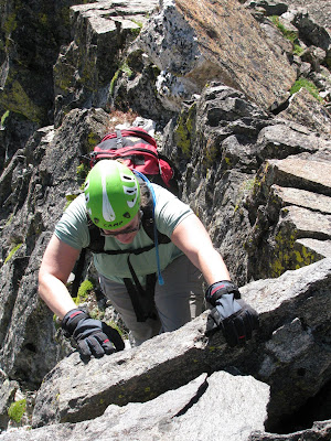
We left the road and began ascending a steep, but mostly grassy knoll that sits below the east ridge of Father Dyer.  Up to the left we could see the "Dyer Straits" ridge (so punny) that connects Helen to Father Dyer.  It did look pretty gnarly.  The East Ridge loomed in front of us, and after a quick break for some fuel, we started up, first Class II, then some Class II+, then finally the Class III jungle gym of rock.  Words cannot possibly express to you how much fun this ridge was to climb.  This was very possibly the most fun I've ever had on a mountain.  I love to climb on rocks!  I'm not afraid of heights, and I don't mind some exposure - there was just enough to give you butterflies in the stomach.  But what I really can't abide is loose rock.  I want to know that the rock I'm using for a handhold or foothold is going to stay put.  And this rock was *solid*.  Very solid, lots of great, deep handholds, plenty of cracks and ledges for footholds.  I was a kid in a candy store.  Observe:


We reached the top of the ridge too soon (it seemed), and made the summit after a short stroll across the talus at the top.  The weather was phenomenally gorgeous, so we lingered to eat another snack, while several begging pikas looked on, hungrily. 


We struck out, then, for Crystal Mountain - the only "real" mountain of the day, rising more than 300 ft from its saddles with both Father Dyer and Crystal.  (The editor would like to point out that this doesn't even matter because Crystal is the tallest one around, so it wins by default.)  It was tedious and sort of annoying work to navigate down and then back up on the blocky talus, especially in the shadow of such a thrilling beginning to the day.  This is funny because I think any other time it would have just been a great day on the mountain.  The other thing was that I had been nursing a moderately severe cough for a few weeks. Somewhere around the ascent up the summit block of Crystal, my lungs started to get really upset at me and I was having some trouble breathing well.  Still, I took my time, and before too long, I made it up to the top of Crystal, with spectacular views of Mohawk Basin, Pacific, Atlantic, and Quandary, complete with toothpick 14er-baggers on top.


We descended to the saddle between Crystal and Peak 10 and reassessed the lung situation before making the call to go ahead and make it a three-peak day.  Since the weather was spectacularly nice - not a cloud in the sky - I felt that we should take advantage and at least make a go of it.  We had "all the time in the world," so I could take my time, which I did.  When I arrived on the summit of Peak 10, I found Jimmy taking a nap.


We had visions of a wide grassy shoulder rolling down to the Wheeler Trail, which we would then pick up and loop back around to the road and our car.  It was *almost* this way.  Except for this one massive downhill section of small scree and rubble.  If there's one thing I dislike more than loose scree and rubble it's *downhill* loose scree and rubble.  And this on tired legs.  We made it down though, and willed our tired aching legs and feet back to the car.  My lungs were wheezy and full of fluid, and Jimmy ended up with a migraine, but it was hard to put a damper on such a great day in the mountains.


I was pregnant with Andrew, but I didn't know it yet.

Sunday, July 18, 2010

Clinton, Traver, and McNamee

Dates of Trip: 18 July 2010
Climbers: hobo, tortoise, Karen, and Beaker
Location: Mosquito Range, CO, USA
Trailhead: Montgomery Reservoir
Summit Objectives: Clinton, Traver, and McNamee
Summits: Clinton Peak at 13857 ft, McNamee Peak at 13780 ft, Traver Peak at 13852 ft
Starting Ele: 10920 ft
Ele. Gain: 3250 ft
Distance: 10.0 mile

We had attempted this moderate day hike back in October, only to be denied by snowy slogging, and the one-two punch of a late start and short daylight.  Assuming that the snow would be now a non-issue, we decided to take advantage of aligning schedules and enjoy a day in the mountains with our friend Karen, who brought along her super-dog, Beaker.  Beaker had an extremely impressive showing, maintaining incredibly high energy throughout the expedition, and apparently not suffering from sore paws.

We made our way up to Wheeler Lake via the mostly-flat-and-very-long Platte Gulch.  After stopping for food at the lake, we began the ascent from the lower basin into the upper basin(s) ringed by the three peaks.  Slightly suspicious clouds drifted in and out of the local sky, but none seemed to do anything about it, so we continued.

Tortoise with Traver.
Tortoise and Karen taking a break.  (Beaker never really took a break.)

Tortoise and Karen ascending the talus.

Beaker waits for her master.


We all four reached the summit of Clinton, where it was warm and calm.  After requisite summit photos and summit register signings, Karen and Beaker decided to drop back down into the basin.  After assessing the weather (fine, but changeable), Hobo and I struck out on the ridge for McNamee, knowing that we could bail before Traver if necessary.  In no time at all we were on top of McNamee, which only has 80' of prominence from the connecting saddle to Clinton, so even though it's named, it technically "doesn't count." as separate.  Bah, I say to that.  On top of McNamee, we commented on how the weather had cleared up nicely, so we headed on over to Traver, (which also "doesn't count" btw - it's only 40' shy of counting, though!).

Clinton's summit.
On McNamee (2nd summit of the day).

Starting up Traver.


Traver has a blockier, crazier summit block and requires some class 2+ scrambling with just enough hairy exposure to give you some butterflies in your stomach.  We knocked that down pretty quickly, and less than an hour since leaving the Clinton summit, we stood on top of Traver.

Clinging to a boulder on Traver's summit block.
On Traver's summit with a plaque to prove it.

Looking back at Clinton from Traver


And not a moment too soon.  Sometime while we were solving the summit block, a great dark cloud had approached from the west.  After snapping our summit photo, we started to hightail it down the ridge.  We'd gotten about 2/3 of the way down from the top to the high basin when we heard the first roll of thunder.  If we hadn't been running with no regard to ankle rolling before, we sure were now.  And roll ankles we did, as well as put feet into creeks and slide uncontrollably down snowfields.  As we dropped down into the "middle" basin, it started to spit rain.  We looked up to check the look of the cloud behind us.... and there was nothing but blue sky.  The storm had passed as quickly as it had come up.

It was pretty much my wildest "getting stormed off a peak" experience to date.  I think it narrowly surpassed the thrill of California Peak, due to the fact that that time, we made it to treeline before the storm broke.

After the rush of adrenaline subsided, we picked our way back down to Wheeler Lake where we filtered some water for the walk out.  The Platte Gulch road is long, hot, and dusty.  We passed three or four 4wd vehicles grinding up the rocks, but alas, none were going down to give us a ride.

Pretty waterfall below Wheeler Lake.

A stop at the Dinky Dairy in Fairplay made my life complete on the way home.

Sunday, July 13, 2008

The Great Gulf

Dates of Trip: 11-13 July 2008
Climbers: hobo and tortoise
Location: Presidential Range, NH, USA
Trailhead: Six Husbands
Summit Objectives: Jefferson, Adams, Madison
Total Time: 10.0 hours
Summit: Adams at 5774 feet, Jefferson at 5712 ft, Madison at 5366 ft
Starting Ele: 1412 feet
Ele. Gain: 5300 feet
Distance: 10.0 mile

Packed in 4 miles up the Great Gulf trail to the Six Husbands/Wamsutta Junction and camped at an established site just beyond. Struck out along Six Husbands by 7:15, and scrambled up Jefferson's Knee to summit Mt. Jefferson. Then took Gulf Side trail across Edmund's Col to Mt. Adams and summitted. From there, a quick jaunt over to Madison Hut and the Mt. Madison summit. We then descended back to the Grest Gulf via The Buttress trail, arriving back in camp just after 5 pm. After one more night in camp, we packed out with very sore quads and soaked in the Peabody River before heading out. Distance/time listed is for summit day, not including pack-in.  Elevation gain is estimated cumulative, including pack in.