Showing posts with label thirteeners. Show all posts

Sunday, August 15, 2010

Father Dyer, Crystal, and Peak 10

Dates of Trip: 15 August 2010
Climbers: hobo, tortoise, and Jimmy
Location: Tenmile Range, CO, USA
Trailhead: Spruce Creek/Wheeler Trail
Summit Objectives: Father Dyer, Crystal, and Peak 10
Summits: Father Dyer Peak at 13615 ft, Crystal Peak at 13852 ft, Peak 10 at 13633 ft
Starting Ele:  11080 ft
Ele. Gain:  ~4000ft
Distance:  ~10 mile

I have a little bit of Class III experience from the past - mostly moves here and there, and a knife edge ridge with some exposure on Katadhin.  We have some more challenging Class III routes on the list, and therefore we went searching for an intermediate Class III experience.  We found it on Father Dyer's East Ridge.  Jimmy, a colleague of hobo's, came along.

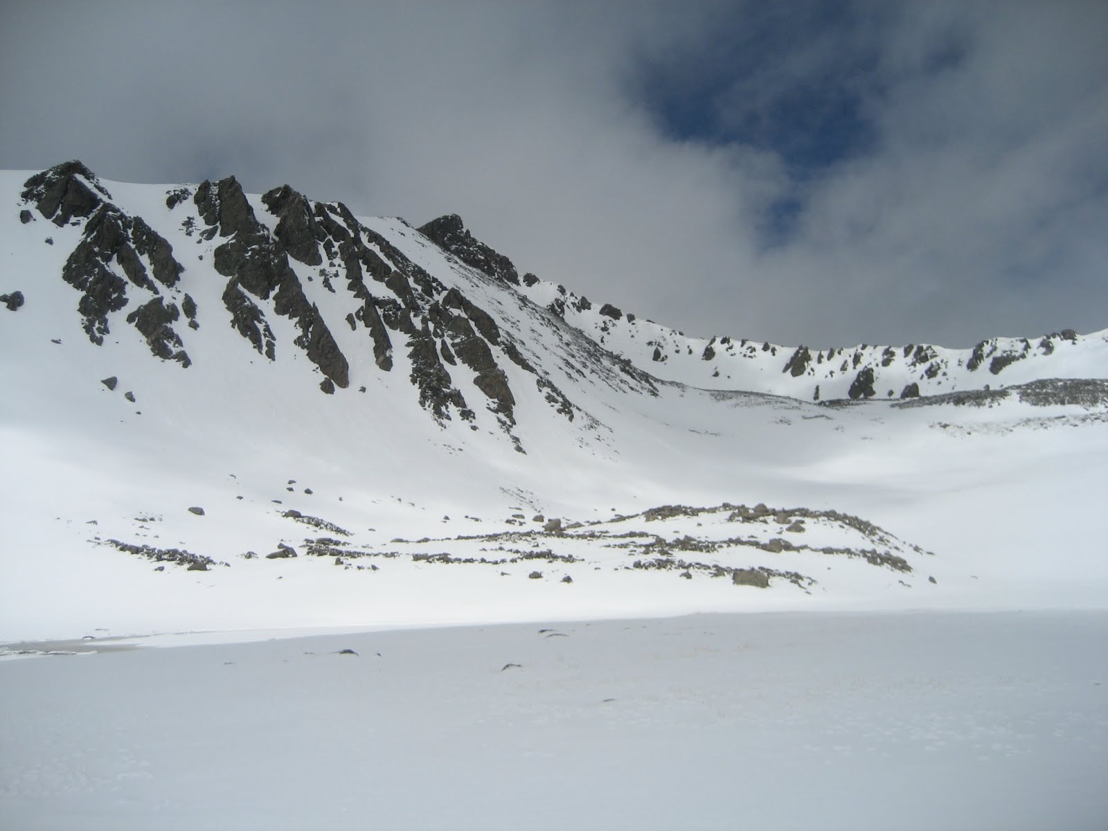
We met up in Idaho Springs and got to the Spruce Creek Trailhead at around 7am, for a nice early start.  This is the same trailhead as the one for Mt. Helen, and in fact, to get to Father Dyer, you hike around the base of Mt. Helen.  But mercifully this time, the road was not blocked by a large pile of snow (it being August and all), and we were able to drive all the way up to the gate at Aqueduct Road.  We followed the Wheeler Trail around the base of Mt. Helen and into the basin surrounded by Father Dyer, Crystal, and Peak 10, our objectives for the day.

We left the road and began ascending a steep, but mostly grassy knoll that sits below the east ridge of Father Dyer.  Up to the left we could see the "Dyer Straits" ridge (so punny) that connects Helen to Father Dyer.  It did look pretty gnarly.  The East Ridge loomed in front of us, and after a quick break for some fuel, we started up, first Class II, then some Class II+, then finally the Class III jungle gym of rock.  Words cannot possibly express to you how much fun this ridge was to climb.  This was very possibly the most fun I've ever had on a mountain.  I love to climb on rocks!  I'm not afraid of heights, and I don't mind some exposure - there was just enough to give you butterflies in the stomach.  But what I really can't abide is loose rock.  I want to know that the rock I'm using for a handhold or foothold is going to stay put.  And this rock was *solid*.  Very solid, lots of great, deep handholds, plenty of cracks and ledges for footholds.  I was a kid in a candy store.  Observe:


We reached the top of the ridge too soon (it seemed), and made the summit after a short stroll across the talus at the top.  The weather was phenomenally gorgeous, so we lingered to eat another snack, while several begging pikas looked on, hungrily. 


We struck out, then, for Crystal Mountain - the only "real" mountain of the day, rising more than 300 ft from its saddles with both Father Dyer and Crystal.  (The editor would like to point out that this doesn't even matter because Crystal is the tallest one around, so it wins by default.)  It was tedious and sort of annoying work to navigate down and then back up on the blocky talus, especially in the shadow of such a thrilling beginning to the day.  This is funny because I think any other time it would have just been a great day on the mountain.  The other thing was that I had been nursing a moderately severe cough for a few weeks. Somewhere around the ascent up the summit block of Crystal, my lungs started to get really upset at me and I was having some trouble breathing well.  Still, I took my time, and before too long, I made it up to the top of Crystal, with spectacular views of Mohawk Basin, Pacific, Atlantic, and Quandary, complete with toothpick 14er-baggers on top.


We descended to the saddle between Crystal and Peak 10 and reassessed the lung situation before making the call to go ahead and make it a three-peak day.  Since the weather was spectacularly nice - not a cloud in the sky - I felt that we should take advantage and at least make a go of it.  We had "all the time in the world," so I could take my time, which I did.  When I arrived on the summit of Peak 10, I found Jimmy taking a nap.


We had visions of a wide grassy shoulder rolling down to the Wheeler Trail, which we would then pick up and loop back around to the road and our car.  It was *almost* this way.  Except for this one massive downhill section of small scree and rubble.  If there's one thing I dislike more than loose scree and rubble it's *downhill* loose scree and rubble.  And this on tired legs.  We made it down though, and willed our tired aching legs and feet back to the car.  My lungs were wheezy and full of fluid, and Jimmy ended up with a migraine, but it was hard to put a damper on such a great day in the mountains.


I was pregnant with Andrew, but I didn't know it yet.

Sunday, July 18, 2010

Clinton, Traver, and McNamee

Dates of Trip: 18 July 2010
Climbers: hobo, tortoise, Karen, and Beaker
Location: Mosquito Range, CO, USA
Trailhead: Montgomery Reservoir
Summit Objectives: Clinton, Traver, and McNamee
Summits: Clinton Peak at 13857 ft, McNamee Peak at 13780 ft, Traver Peak at 13852 ft
Starting Ele: 10920 ft
Ele. Gain: 3250 ft
Distance: 10.0 mile

We had attempted this moderate day hike back in October, only to be denied by snowy slogging, and the one-two punch of a late start and short daylight.  Assuming that the snow would be now a non-issue, we decided to take advantage of aligning schedules and enjoy a day in the mountains with our friend Karen, who brought along her super-dog, Beaker.  Beaker had an extremely impressive showing, maintaining incredibly high energy throughout the expedition, and apparently not suffering from sore paws.

We made our way up to Wheeler Lake via the mostly-flat-and-very-long Platte Gulch.  After stopping for food at the lake, we began the ascent from the lower basin into the upper basin(s) ringed by the three peaks.  Slightly suspicious clouds drifted in and out of the local sky, but none seemed to do anything about it, so we continued.

Tortoise with Traver.
Tortoise and Karen taking a break.  (Beaker never really took a break.)

Tortoise and Karen ascending the talus.

Beaker waits for her master.


We all four reached the summit of Clinton, where it was warm and calm.  After requisite summit photos and summit register signings, Karen and Beaker decided to drop back down into the basin.  After assessing the weather (fine, but changeable), Hobo and I struck out on the ridge for McNamee, knowing that we could bail before Traver if necessary.  In no time at all we were on top of McNamee, which only has 80' of prominence from the connecting saddle to Clinton, so even though it's named, it technically "doesn't count." as separate.  Bah, I say to that.  On top of McNamee, we commented on how the weather had cleared up nicely, so we headed on over to Traver, (which also "doesn't count" btw - it's only 40' shy of counting, though!).

Clinton's summit.
On McNamee (2nd summit of the day).

Starting up Traver.


Traver has a blockier, crazier summit block and requires some class 2+ scrambling with just enough hairy exposure to give you some butterflies in your stomach.  We knocked that down pretty quickly, and less than an hour since leaving the Clinton summit, we stood on top of Traver.

Clinging to a boulder on Traver's summit block.
On Traver's summit with a plaque to prove it.

Looking back at Clinton from Traver


And not a moment too soon.  Sometime while we were solving the summit block, a great dark cloud had approached from the west.  After snapping our summit photo, we started to hightail it down the ridge.  We'd gotten about 2/3 of the way down from the top to the high basin when we heard the first roll of thunder.  If we hadn't been running with no regard to ankle rolling before, we sure were now.  And roll ankles we did, as well as put feet into creeks and slide uncontrollably down snowfields.  As we dropped down into the "middle" basin, it started to spit rain.  We looked up to check the look of the cloud behind us.... and there was nothing but blue sky.  The storm had passed as quickly as it had come up.

It was pretty much my wildest "getting stormed off a peak" experience to date.  I think it narrowly surpassed the thrill of California Peak, due to the fact that that time, we made it to treeline before the storm broke.

After the rush of adrenaline subsided, we picked our way back down to Wheeler Lake where we filtered some water for the walk out.  The Platte Gulch road is long, hot, and dusty.  We passed three or four 4wd vehicles grinding up the rocks, but alas, none were going down to give us a ride.

Pretty waterfall below Wheeler Lake.

A stop at the Dinky Dairy in Fairplay made my life complete on the way home.

Sunday, July 4, 2010

Mt. Silverheels and Little Baldy

Dates of Trip: 3-4 July 2010
Climbers: hobo and tortoise
Location: Mosquito Range, CO, USA
Trailhead: Gold Dust
Summit Objectives: Mt. Silverheels and Little Baldy
Summits: Little Baldy at 12142 ft, Mt. Silverheels at 13882 ft
Starting Ele: 10330 ft
Ele. Gain: 4500 ft
Distance: 12.6 mile

We were planning to head to Jasper for a 3 night backpack of the Skyline Trail on 8 July.  Problem was, we hadn't packed into anything in quite some time.  So we decided to take a shakedown trip over the holiday weekend, and bag some summits we'd been meaning to get, besides.  (Silverheels has been on our list for a loooong time, since we met.)

So on the morning of July 3rd, just as it was starting to get hot at the lower elevations, we headed up past Como to the Gold Dust Trailhead.  We had opted for winter mountaineering pants, anticipating snow and cold temperatures at elevation... but this turned out to be a poor choice.  It was HOT.  Ah well, this is the reason you do a shakedown trip, right?

HOT.

We packed in about two miles to the saddle between Little Baldy and Silverheels and set up camp in a small stand of trees on the breezy saddle at approximately 11,200ft.  That done, and a lunch of beef jerky had, and we were ready to tackle Little Baldy.  This involved a scamper through the shadowy, mosquito-y forest that covered the base of the mountain, and then seemingly straight up the side to the summit.  All of the elevation gain in about a half a mile (this turned out to be excellent training for The Notch on the Skyline Trail the following weekend).  The summit was a rocky pile of talus, and we sat in the wind and surveyed Como and Fairplay.


Summit photo.  Where we lost the cap to the Nalgene, may it rest in peace

Before too long, dayhikers were coming up the standard route in their jeans and sneakers, so we skedaddled down the steep slope and ran the mosquito gauntlet back to camp.

Sleeping at 11,200 went much much better this week than sleeping at 12,000 ft had the previous week.  This was likely a combination of factors.  (1) We had attempted to sleep at 12,000ft the previous week.  (2) We had obeyed the "climb high, sleep low" adage.  (3) We had worked hard that day, instead of just driving up from our desk jobs.  We slept like logs.

We got an early start (with the sunrise) up the East Ridge of Mt. Silverheels, a gorgeous class 1 walk up with spectacular views.  We ran into 3 mountain goats on the way up, who sort of looked like they were going to approach us.  I said, "I know how to deal with bears and mountain lions... but how does one fend off a goat?!"  Luckily (?) they kept their distance.

Skeleton trees and the Silverheels summit


Goats

From the broad, beautiful Silverheels summit, we had spectacular views of Hoosier Ridge, and many of our favorite Front Range, Mosquito Range, and Ten Mile Range summits, which are too numerous to list here.  It was a superbly clear day, and we could see to the southern Sawatch range, and on Independence Day, we had a patriotic view of Pike's Peak (the inspiration for "purple mountain majesty" in America the Beautiful).  We enjoyed a long 20 minute stay on the summit (long by our standards - it's usually freezing), signed the summit register, and descended to the saddle.  We packed up camp and hiked out, feeling thoroughly ready for Skyline and Jasper.  Bring it on.

Signing the summit register.
"For purple mountain majesty..."

Sunday, June 20, 2010

Mt. Sheridan and Peerless Mountain

Dates of Trip: 19-20 June 2010
Climbers: hobo and tortoise
Location: Mosquito Range, CO, USA
Trailhead: Horseshoe Basin
Summit Objectives: Horseshoe Mtn, with options on Sheridan, Peerless, and Finnback Knob
Summits: Mt. Sheridan at 13748 ft, Peerless Mountain at 13348 ft
Starting Ele: ~12000 ft
Ele. Gain: ~2500 ft
Distance: ~4.0 mile

We originally set out to ascend the Boudoir Couloir on Horseshoe Mtn in a "moderate" snow climb. This was one of the last weekends that it was expected to be available, as the snow would likely be melting out for the summer. Indeed, when we got into Horseshoe Basin, snow in the couloir was a very thin line, the temperature was warm, and as this was our first climb in quite sometime, we decided it wasn't the best idea to make an attempt on that particular route.

We were able to get the jeep all the way up into Horseshoe Basin at 12000 ft by four-wheeling it up the old mine access roads, This involved a couple sketchy, bouldery uphills, and several splashes through very large puddles of standing water in the road. It was a gorgeously scenic place to camp, and we were excited to be trying out our new winter mountaineering tent. The scene looked like an REI ad, or a Jeep ad, or both.

Boudoir Couloir is visible just above the right side of the tent.


Unfortunately, even with our acclimitization to 7200ft (at our house), driving straight up to 12000ft after not having been up so long was problematic.  We both had a really rough night of very little sleep and altitude sickness symptoms.  When the alarm went off at 4am, I was like, "Thank God!  I don't have to try to sleep anymore!"

We were feeling pretty nasty, which cemented our decision to forgo the Boudoir, but it is a well known fact that bad mornings on a mountain can turn into good days, so we began trudging up the mine roads towards the Horseshoe/Peerless saddle, figuring we'd decide which peaks to go for when we gained the ridge.  By the time we got there, we felt much better, so we chose to begin with the long hike (over Peerless to Sheridan), and either grab Horseshoe at the end or save it for when we could climb the couloir.

Tortoise, on the ridge, approaching Peerless
Peerless is pretty much just a bump on the ridge between Horseshoe and Sheridan, but it was a fun way to start any thing.  We hadn't stood on top of something in quite a while and the sense of accomplishment was strong.

Peerless Summit

From there, it was very easy to be enthusiastic about the beautiful day, and the prospect of bagging a bicentennial 13er.  So we tromped on over across the ridge and up the steep side of Sheridan, with great views of Sherman (where apparently there was a rousing cornhole game going on), Silverheels (which we would climb two weeks later), and Dyer (our first mountain together).

Sheridan Summit

Satisfied with the success of a short hike-and-summit to break us into the summer climbing season, and indeed back into climbing in general, we headed back down to the Jeep and home.  A celebratory stop at the Dinky Dairy in Fairplay was thoroughly enjoyed.

Friday, October 16, 2009

Attempt on Clinton/Traver/McNamee

Dates of Trip: 16 October 2009
Climbers: hobo and tortoise
Location: Ten Mile Range, CO, USA
Trailhead: Wheeler Lake
Summit Objectives: Clinton, Traver, and McNamee

The trail from Montgomery Reservoir to Wheeler Lake is pretty long and relatively flat. Once you get up to the lake at 12,100', the "trail" turns sharply uphill. This would have been a workout, but not a problem, if we hadn't slogged through some moderate snow up to the lake, and then floundered through thigh-deep snow up the hill. By the time we reached the basin below the peaks at 12,500 or so, we were exhausted, wet, and perplexingly running short on daylight. Conservatively, we chose to turn back. It's possible that snowshoes would have made some difference, but it's also possible that we just plain old didn't get an early enough start.

Still, it was a beautiful day to be out in the mountains, getting some fresh air, and playing in the snow, and a good welcome to the winter climbing season.


Monday, May 25, 2009

Attempt on Pacific and Crystal

Dates of Trip: 23-24 May 2009
Climbers: hobo and tortoise
Location: Ten Mile Range, CO, USA
Trailhead: Spruce Creek
Summit Objectives: Pacific, Atlantic, Crystal, and Father Dyer

After a fabulous climb at Mt. Hope the previous week, we decided to strike out again in search of another snow climb. Pacific's Northeast face seemed a perfect opportunity for it, along with a short pack-in with easy access to several other peaks. Conditions in the Sawatch had been mostly dry with patchy snow fields to just below 12,000 ft with couloirs holding snow well up to 14,000, and we expected similar for the Ten Mile/Mosquito area. It was not so.

We made it about halfway up the 4WD road at Spruce Creek in the Jeep before being denied by snow. Additionally, the snowy road conditions induced us to bring the snowshoes, in addition to crampons and ice axes. The trail conditions were mixed up to Lower Mohawk Lake at ~11,000 - on with the snowshoes, then off again, then on, then off. We made it up the headwall to the lake, and the trail seemed snowcovered from there, so we chose to set up camp. While our homemade dehydrated cuisine soaked a bit (Curried Lamb with Couscous... yum!!), we ventured out sans packs to scope the next day's route and break trail. Hobo made it nearly fully up the next headwall to Upper Mohawk Lake and called it good.


It snowed/sleeted/rained on and off most of the night.

The next morning, it turned out that our scouting/trail breaking paid off in spades, as it was an easy push up a potentially frustrating headwall. We proceeded across vast snowfields to the base of Pacific's Northeast face at ~12,500, abandoned poles for ice axes, and began kicking steps up the face. We chose to stay with the snowshoes instead of crampons, due to the 4-6 inches of fresh powder on top from the storms the night before. We were clearly punching right through that fresh layer to the more consolidated layer beneath. We recognized that there might be some avalanche danger, but it was early and all other conditions seemed good, so we proceeded. To avoid as much danger as possible, we climbed under a rock band, instead of in the middle of the "chute."

We made it up to the rock band and stopped for a break -- it was hard work. We were about halfway up at 12,900. At that point, conditions were seeming to deteriorate. The slope got steeper. Kicking steps became much more laborious and we were driving much deeper into soft snow - not a good sign. I (tortoise), in the lead, began kicking off small rollers. As the sun came up, it was quickly warming, and the snow pack, which clearly never got a really hard freeze the night before, was only getting softer.

After some discussion we opted to turn around due to perceived avalanche danger. We flipped over and had a spectacular glissade back down to our poles. Denied Pacific (and by the connecting ridge, Atlantic), we made for Crystal (and by its connecting ridge, Father Dyer) which was to be our next day's objective. We tramped across virgin snowfields in the basin, breaking trail. We were the first hikers to venture beyond Lower Mohawk Lake in sometime, judging by the utter lack of footprints. We reached Crystal's base and began ascending by contouring the side of the basin, when it began to snow in earnest, this time with a wind behind it, even as the snow on the slopes continued to soften. Judging that the conditions were just poor, and weren't likely to improve the next day, we reluctantly turned back, deciding to pack out and get home in time for the basketball game.


When we got back to camp, the sun was out, and it was a hot 70 degrees. We laid out our wet gear to dry as much as possible while we fixed up a hot lunch of corn chili. While we were busy at camp, we heard a rumble and watched an avalanche release in a couloir on one of the nearby ridges. Seeing that only cemented the conviction that we had done the right thing in turning around, not only on Pacific, but also on Crystal.

Then, while we were eating lunch, another round of storm blew in. When it was clear that this one wasn't going to blow out again in two minutes, we scrambled to get our gear and ourselves under the (mercifully still pitched) tent. We huddled in the tent for nearly an hour while the sleet and wind buffeted us. When it finally broke, we packed up in a whirlwind and made a dash down the mountain.

Amazingly, most of the trail below the lake, including down the headwall, was nearly snow free. What a difference a day (and some rain) makes! Of course, the snow was replaced by mud, which presents its own logistical challenges (e.g. if you fall in it, it will suck), but it was a quick hour for the 2 miles back to the Jeep.

Though we failed to bag any peaks, we left convinced that this will be a great place to return, after the snow has melted out of the basin. Maybe later this summer, we'll pack in all the way up to the basin. Pacific's northeast face holds snow into August, so we may get our snow climb in yet!