Showing posts with label colorado. Show all posts

Saturday, September 3, 2022

Mt Bierstadt

 Date of Trip: 3 September 2022
Climbers: Travis, Clara, Trevor, and G
Location: Front Range, CO, USA
Trailhead: Guanella Pass
Summit Objective: Mt. Bierstadt
Total Time: 7.0 hours
Summit: Bierstadt at 14,065'
Ele. Gain: 2850 feet
Distance: 7.5 mile


Written by Travis

Clara and I headed back to the mountains today to climb 14er Mt. Bierstadt. This time we invited Clara's classmate and carpool buddy G and his dad Trevor. It was Clara's 4th 14er and G's first.  They were both rock stars. 

We arrived at the trailhead at 720am, and sort of amazingly were still able to park fairly close to the trailhead, albeit along the road.  We were on the trail at 730. 

We soon got to see a moose foraging among the willows.  I don't think I've ever seen a moose while climbing a 14er.  To be fair, we wouldn't have seen this one, except some other people had tracked it all morning with a telescope as it wandered from the lake, so we knew where to look.  

We then kept moving through the willows. There are boardwalks now that make it so easy. "Back in my day" finding your way through the willows was literally the crux of the route!  

The trail was packed as usual. Owing to the proximity to Denver, and its relative ease, it's one of the most climbed 14ers. We don't go for solitude.

In addition to my first moose sighting, I also saw my first supplemental oxygen use on a 14er.  You read that right.  A woman was carrying a small canister with a mouth piece as she was slogging up the trail.  I didn't see her use it, but she had it at the ready! (Another guy had one in the pocket of his pack on the way down, kind of like you would carry bear spray.) Now mind you, I just had a friend from MIT climb K2 --  the second tallest mountain in the world, literally twice as high at 28,000' -- WITHOUT SUPPLEMENTAL OXYGEN. But here we are.  

We kept going up. The kids started slowing down, so I busted out the energy chews (basically gummies for adults). That did the trick. Then we reached the summit ridge, and the Class II to the top began. It's funny how Clara can be dragging, but as soon as we transition from boring hiking to rock scrambling, she finds her next gear. "Dad, can we just do more of this?"

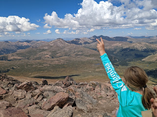
We summited shortly before noon, and commenced celebrating G's first 14er. And Clara's 4th (including 3 within 8 days). 

Even before making it to the top, G had declared his goal of climbing all 58 Colorado 14ers by the time he's 41. He also told us (a few times) that this was "the most wonderful thing he has ever done in his life." 

It took me back to my first time summiting a 14er (Mt Elbert, 2000).  And all the friends of mine who climbed their first 14er on a trip with me.  And how he'll probably remember this day for the rest of his life. And how at this point, that's the stuff I really care about. Me summiting this peak for the 3rd time (or is it 4?) is kind of secondary.

The weather was just about perfect, zero wind, so we hung out for nearly 30 mins. The voice in my head said you know better than this.... 

And sure enough, that voice was soon telling me "I told you so" when it started clouding up big time.  Then it was thundering. We were well on our way down by now, nearly off the eastern shoulder, mostly safe, but it was still unnerving. Clara and I started jogging down the trail. We were back in the willows as it started to rain and then pea-size hail. There was occasional lightning on the ridges around us, none too close. I'll have to add this to the list of peaks I've been stormed off (Holy Cross, Crestone Needle, maybe more)

We made it back to the van at 230pm, 7 hours after setting out. G and Trevor soon followed.


Saturday, August 27, 2022

Grays and Torreys - Travis and Clara

Date of Trip: 27 August 2022
Climbers: Travis & Clara 
Location: Front Range, CO, USA
Trailhead: Grays Peak
Summit Objectives: Grays and Torreys
Total Time: 8.0 hours
Summit: Grays at 14270 feet, Torreys at 14267 feet
Starting Ele: 11280 feet)
Ele. Gain: 3667 feet
Distance: 8.5 mile

Written by Travis


With little more than an hour of planning, Clara and I headed out Friday night for a Daddy-Daughter backpacking-mountainering trip.  We decided we would pack-in for about a mile Friday night, camp, and then attempt to summit two 14,000' peaks on Saturday, Gray's and Torrey's (which are generally considered two of Colorado's easiest 14ers, out of the 58). Amy and the boys were staying home to rest and recover, as the middle school transition, in particular, has not been easy.  
We arrived at the trailhead at 630pm Friday evening in a driving rain. It's been a crazy monsoon summer in the mountains, and there was water flowing everywhere. Worse, it looked like it could keep it up all night. I was considering bailing completely, or at least camping in the Tahoe at the trailhead. But after about 45 mins, it did stop. And the forecast was for great weather today, so we set out. 
We made it past the willows and took about the first flattish spot we could find so as to get the tent up before dark.  Few really pack-in on these mountains (easily done in a day) so nobody was around, but there also aren't really any established sites. It was in the 40s and damp (very un-Colorado!) Clara was cold so we got her in the tent and into a sleeping bag while I cooked dinner just outside the vestibule.  I then filled her Nalgene bottle with boiling water to take to bed, a trick which she thought was amazing.  
The GPS said we were at 12,000'.  I remembered that I never sleep well at 12,000'. This trip was no exception.  We were about 100' off the trail, so we had people walking by shining headlamps at us, and talking, starting at 330am.  I cancelled the alarm I had set for 6, but at 645a, I figured we should get up. Clara said she didn't really feel like climbing a mountain, because of the bad night of sleep. I said, yeah, that's kind of how mountaineering goes. I never sleep well the night before a climb.  Amy and I have a saying, "the best days on the mountain often follow the worst nights".  
Well, she decided she'd give it a go. But only if we had some ramen for breakfast. Deal! I cooked it without leaving my sleeping bag. (It was 30s outside, ice on the tent fly, and the light rain that fell on us was apparently snow up on the mountain).  
We joined the conga line marching past us on the trail at 715am.  We stopped to filter water at the first stream access around 745 (we could hear the water at our hastily chosen campsite, but it was maybe a couple hundred yards away, so we used what I packed in).  
We headed on up to Gray's Peak.  I always do Gray's first for some reason -- maybe because it's Gray's and Torrey's, not Torrey's and Gray's? Clara kept saying she didn't think she wanted to do Torrey's too, so I kept reminding her to focus on the goal of Gray's and that we'd worry about Torrey's later.  We passed the mountain goats in their usual spot on the shoulder toward Edwards. It was a mamma and a kid. Clara also counted 7 pikas on the day. 
Eventually we summited Gray's. The trace of snow and ice had mostly turned to slush by now, so no big deal.  The weather was great as forecast, just some typical wind.  
Gray's was Clara's 2nd 14er, having done Sherman with Amy in 2020. (I had taken the boys back to the car as we feared Nate might be literally blown off the mountain that day.) Anyway, Clara was amazing. She was not the youngest on the summit though as there was a 9 year old girl tagging her 3rd 14er (she had just come over from Torrey's). 
We took some pics (including with the provided signs and brick, lol) and headed down to the saddle between the peaks.  I was pretty sure a little downhill would have Clara ready to go up again and indeed that was the case.  I told it her it always looks harder than it really is. She actually thought Torrey's was easier, because there are less switchbacks, just UP. More pics with provided signs and brick. (I'm so old that I remember when you had to try to remember what mountain you were on in each summit pic!)


We headed down, collecting my cached backpack at the saddle, then the water filter at the stream, before arriving at the tent. The crowds had mostly dissipated by now, but the weather was still perfect. Probably 50's at the tent, with an intense sun. Clara asked for a post-climb snack of mashed potatoes, so I whipped them up before packing up camp. Then we headed out the final 1 mile, getting to the truck at about 3 I think. Did I mention I was exhausted? Maybe this is how I always felt at the end of a day of 14ers, hard to say. Overall, it was a fantastic trip. Clara did her first overnight mountaineering trip and got her 2nd and 3rd fourteeners, and her first "two-fer". I can't be more proud of her. She's learning what it's like to carry a pack, be cold, sleep like crap, and yet that climbing mountains mostly boils down to putting one foot in front of the other, over and over again. I think I got my third climb of G-T (first with my buddy Terry in 2000 then with Amy in 2008 when we missed the turn to 13er Mt Edward's and "settled" for G-T. Maybe more, but that's what I remember at least.) And my first 14er summit in 7 years, my first fourteener post ACL tear #2, and first 14er in my 40's. Still at 42 of 58 overall I think but it's not really about me these days and that's just fine. 8.5 miles round trip. 3667' of elevation gain Clara's wildlife count: 7 pikas 2 mountain goats 2 chipmunks Couple dozen dogs, some of which were even on a leash One injured dog being carried down in a backpack Too many humans to count

Sunday, August 21, 2022

High Line Canal - Segments 2 & 3


 Date of Trip: 21 August 2022
Adventurers: Travis, Amy, Andrew, Clara, Nate
Location: Douglas County, CO, USA
Trailhead: Highline Canal - Waterton Trailhead
Trip Objectives: Highline Canal - Segments 2&3
Total Time: 2.5 hours
Distance: 9.7 mile


We've started a new family adventure project - to section-cycle the Highline Canal Trail, a 71-mile mixed use trail that runs next to a historic irrigation ditch that enabled the settlement of Denver. Segment 1 is in Waterton Canyon, which we have biked many times. Today we tackled sections 2 & 3 on the southern edge of Chatfield State Park. It was a fun ride on a glorious day! ... Until 1.5 miles before our end point, I noticed that Nate's rear tire was flat. 
He and I walked back to the shelter where Travis was going to pick us up in the van after riding fast back to the start. When I explained to Andrew and Clara what took us so long, they said, "Oh we both have flat tires too!" And Travis said, "yeah my front tire went flat."
After thoroughly inspecting all tires at home, it appears we rode through a patch of thorns. Out of 10 tires on this expedition, only 2 tubes survived. I thought I had escaped, but really there was just a thorn in my back tire sealing the hole it had made. 
So we spent the afternoon on bike maintenance -- picking thorns out of tires and replacing tubes. Oops!


Saturday, September 24, 2011

Spearhead Mountain


Dates of Trip: 24 September 2011
Climbers: hobo, tortoise, and bug (<5 months old)
Location: Mt. Evans Wilderness, Pine National Forest, CO, USA
Trailhead: Threemile Creek
Summit Objectives: Spearhead
Summits: Spearhead Mountain at 11244 ft
Starting Ele:  8960 ft
Ele. Gain:  ~2300ft
Distance:  6.75 mi

Aaaaaaaand, we're back!  After a beautiful pregnancy, a wonderful birth, and some recovery time, we are back in the hiking/climbing saddle with a third climber(-to-be) in tow.

Bug had done 2 nights of camping prior to this one, but we still hadn't been successful at getting the gumption for a hike afterward.  We took advantage of the fact that it is now fall, kids are back in school, and therefore the close-in dispersed camping is much easier to come by.  We camped at an established dispersed campsite along Guanella Pass Road on the banks of Geneva Creek.

Camp next to Geneva Creek

Hobo cookin', Bug rollin'

Bug put himself to sleep by hanging onto the zipper pull on the tent door.

Happy camping family

It's Cold!
In the morning we proceeded to the Threemile Creek trailhead early.  It was pretty chilly, and Bug was bundled up.  We did a long sleeved onesie as base layer, then a fleece sleeper, thick socks over that, cotton newborn mittens (need to get some fleece ones!) and his fleece hat with the earflaps.  Then we draped a fleece blanket over him once he was in the carrier.  It was his first outing in the Deuter frame backpack carrier, and he did great!  He fell asleep a couple times and fussed when he was hungry, but mostly he seemed to enjoy the scenery.  


The fall colors were in full splendor - we walked through several groves of glowing golden aspens.


Once we reached the base of Spearhead's summit cone, we determined (as expected) that the final push was a little too steep and bushwhack-y to bring the baby up.  So Hobo ran up to the summit while I waited with bug around 10800 and ate lunch.  I was contemplating saying that the hike had been enough for me, I didn't need the summit, when Hobo came back and declared "best summit register ever!!!" and told me I HAD to go.  So Bug stayed with daddy while I made my summit push.  I was very slow, but I made it and indeed it was worth it.

Waiting for daddy.

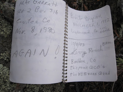
First of all, the summit register was in an old food jar of some kind.  The register itself was a small pocket notebook labelled "Woolworth's. 19c."  Classic!  The first page showed it had been placed in 1976.  There were very few entries (maybe 15 or so?) between then and now.  


Then, on page 3, appeared the name of Gerry Roach.  As in THE Gerry Roach - authority on all things Colorado Mountaineering, author of some of our favorite books, 12th American to summit Mt. Everest, 2nd person to complete the seven summits (highest peak on every continent), international mountaineering icon... Gerry Roach.  His summit log was dated October 8, 1983... just a few short months after he summitted Everest.  A-MAZING.  We have signed the same summit register as Gerry Roach.


It was just a beautiful day and a really fun hike.  It was "only" an 11er, but it was a challenge (I was SO sore the next day), and it was really great to stand on top of something again.


Saturday, August 28, 2010

San Luis Peak

Dates of Trip: 28 August 2010
Climbers: hobo and tortoise
Location: San Juan Range, CO, USA
Trailhead: West Willow Creek
Summit Objectives: San Luis
Summits: San Luis Peak at 14019 ft
Starting Ele:  11500 ft
Ele. Gain:  ~3700ft
Distance:  11 mi

We drove out to the old mining town of Creede after work on Friday - a gorgeous drive.  We drove up the box canyon just north of Creede in the dark, the old mine ruins looming in the shadows.  We camped at what we thought was the trailhead and had a very pleasant night.

In the morning we discovered we were about a half mile from the trailhead, so we followed the other 14er baggers (not *too* many, as this is a non-standard route) to the trailhead at the end of the road and got on the trail.

This is a long-ish hike, as many in the San Juans are, but gentle and very scenic, cresting two passes before the summit push and contouring around their valleys.  There is a very disappointing section of significant elevation loss after the first mile or so, but other than that, it's very satisfying.

We made good time to the summit and spent about 20 minutes there, eating lunch and chatting with other hikers, and then rather suddenly, the sky started to cloud up and the temperature dropped.  There were still people on their way up, but we took the opportunity to drop down, quickly.  We got a few spatters of rain, but nothing too serious.  Still, we were in a hurry to get to a safer elevation and more protected area.

I got rather fatigued toward the end (which I'm blaming on being 5 weeks pregnant), which made the push back up that segment about a mile from the trailhead quite a slog, but I made it.  It was a really fun hike.

We ate dinner at a hippy burger joint in Creede before driving home that evening.


Sunday, August 15, 2010

Father Dyer, Crystal, and Peak 10

Dates of Trip: 15 August 2010
Climbers: hobo, tortoise, and Jimmy
Location: Tenmile Range, CO, USA
Trailhead: Spruce Creek/Wheeler Trail
Summit Objectives: Father Dyer, Crystal, and Peak 10
Summits: Father Dyer Peak at 13615 ft, Crystal Peak at 13852 ft, Peak 10 at 13633 ft
Starting Ele:  11080 ft
Ele. Gain:  ~4000ft
Distance:  ~10 mile

I have a little bit of Class III experience from the past - mostly moves here and there, and a knife edge ridge with some exposure on Katadhin.  We have some more challenging Class III routes on the list, and therefore we went searching for an intermediate Class III experience.  We found it on Father Dyer's East Ridge.  Jimmy, a colleague of hobo's, came along.

We met up in Idaho Springs and got to the Spruce Creek Trailhead at around 7am, for a nice early start.  This is the same trailhead as the one for Mt. Helen, and in fact, to get to Father Dyer, you hike around the base of Mt. Helen.  But mercifully this time, the road was not blocked by a large pile of snow (it being August and all), and we were able to drive all the way up to the gate at Aqueduct Road.  We followed the Wheeler Trail around the base of Mt. Helen and into the basin surrounded by Father Dyer, Crystal, and Peak 10, our objectives for the day.

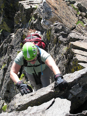
We left the road and began ascending a steep, but mostly grassy knoll that sits below the east ridge of Father Dyer.  Up to the left we could see the "Dyer Straits" ridge (so punny) that connects Helen to Father Dyer.  It did look pretty gnarly.  The East Ridge loomed in front of us, and after a quick break for some fuel, we started up, first Class II, then some Class II+, then finally the Class III jungle gym of rock.  Words cannot possibly express to you how much fun this ridge was to climb.  This was very possibly the most fun I've ever had on a mountain.  I love to climb on rocks!  I'm not afraid of heights, and I don't mind some exposure - there was just enough to give you butterflies in the stomach.  But what I really can't abide is loose rock.  I want to know that the rock I'm using for a handhold or foothold is going to stay put.  And this rock was *solid*.  Very solid, lots of great, deep handholds, plenty of cracks and ledges for footholds.  I was a kid in a candy store.  Observe:


We reached the top of the ridge too soon (it seemed), and made the summit after a short stroll across the talus at the top.  The weather was phenomenally gorgeous, so we lingered to eat another snack, while several begging pikas looked on, hungrily. 


We struck out, then, for Crystal Mountain - the only "real" mountain of the day, rising more than 300 ft from its saddles with both Father Dyer and Crystal.  (The editor would like to point out that this doesn't even matter because Crystal is the tallest one around, so it wins by default.)  It was tedious and sort of annoying work to navigate down and then back up on the blocky talus, especially in the shadow of such a thrilling beginning to the day.  This is funny because I think any other time it would have just been a great day on the mountain.  The other thing was that I had been nursing a moderately severe cough for a few weeks. Somewhere around the ascent up the summit block of Crystal, my lungs started to get really upset at me and I was having some trouble breathing well.  Still, I took my time, and before too long, I made it up to the top of Crystal, with spectacular views of Mohawk Basin, Pacific, Atlantic, and Quandary, complete with toothpick 14er-baggers on top.


We descended to the saddle between Crystal and Peak 10 and reassessed the lung situation before making the call to go ahead and make it a three-peak day.  Since the weather was spectacularly nice - not a cloud in the sky - I felt that we should take advantage and at least make a go of it.  We had "all the time in the world," so I could take my time, which I did.  When I arrived on the summit of Peak 10, I found Jimmy taking a nap.


We had visions of a wide grassy shoulder rolling down to the Wheeler Trail, which we would then pick up and loop back around to the road and our car.  It was *almost* this way.  Except for this one massive downhill section of small scree and rubble.  If there's one thing I dislike more than loose scree and rubble it's *downhill* loose scree and rubble.  And this on tired legs.  We made it down though, and willed our tired aching legs and feet back to the car.  My lungs were wheezy and full of fluid, and Jimmy ended up with a migraine, but it was hard to put a damper on such a great day in the mountains.


I was pregnant with Andrew, but I didn't know it yet.

Sunday, July 18, 2010

Clinton, Traver, and McNamee

Dates of Trip: 18 July 2010
Climbers: hobo, tortoise, Karen, and Beaker
Location: Mosquito Range, CO, USA
Trailhead: Montgomery Reservoir
Summit Objectives: Clinton, Traver, and McNamee
Summits: Clinton Peak at 13857 ft, McNamee Peak at 13780 ft, Traver Peak at 13852 ft
Starting Ele: 10920 ft
Ele. Gain: 3250 ft
Distance: 10.0 mile

We had attempted this moderate day hike back in October, only to be denied by snowy slogging, and the one-two punch of a late start and short daylight.  Assuming that the snow would be now a non-issue, we decided to take advantage of aligning schedules and enjoy a day in the mountains with our friend Karen, who brought along her super-dog, Beaker.  Beaker had an extremely impressive showing, maintaining incredibly high energy throughout the expedition, and apparently not suffering from sore paws.

We made our way up to Wheeler Lake via the mostly-flat-and-very-long Platte Gulch.  After stopping for food at the lake, we began the ascent from the lower basin into the upper basin(s) ringed by the three peaks.  Slightly suspicious clouds drifted in and out of the local sky, but none seemed to do anything about it, so we continued.

Tortoise with Traver.
Tortoise and Karen taking a break.  (Beaker never really took a break.)

Tortoise and Karen ascending the talus.

Beaker waits for her master.


We all four reached the summit of Clinton, where it was warm and calm.  After requisite summit photos and summit register signings, Karen and Beaker decided to drop back down into the basin.  After assessing the weather (fine, but changeable), Hobo and I struck out on the ridge for McNamee, knowing that we could bail before Traver if necessary.  In no time at all we were on top of McNamee, which only has 80' of prominence from the connecting saddle to Clinton, so even though it's named, it technically "doesn't count." as separate.  Bah, I say to that.  On top of McNamee, we commented on how the weather had cleared up nicely, so we headed on over to Traver, (which also "doesn't count" btw - it's only 40' shy of counting, though!).

Clinton's summit.
On McNamee (2nd summit of the day).

Starting up Traver.


Traver has a blockier, crazier summit block and requires some class 2+ scrambling with just enough hairy exposure to give you some butterflies in your stomach.  We knocked that down pretty quickly, and less than an hour since leaving the Clinton summit, we stood on top of Traver.

Clinging to a boulder on Traver's summit block.
On Traver's summit with a plaque to prove it.

Looking back at Clinton from Traver


And not a moment too soon.  Sometime while we were solving the summit block, a great dark cloud had approached from the west.  After snapping our summit photo, we started to hightail it down the ridge.  We'd gotten about 2/3 of the way down from the top to the high basin when we heard the first roll of thunder.  If we hadn't been running with no regard to ankle rolling before, we sure were now.  And roll ankles we did, as well as put feet into creeks and slide uncontrollably down snowfields.  As we dropped down into the "middle" basin, it started to spit rain.  We looked up to check the look of the cloud behind us.... and there was nothing but blue sky.  The storm had passed as quickly as it had come up.

It was pretty much my wildest "getting stormed off a peak" experience to date.  I think it narrowly surpassed the thrill of California Peak, due to the fact that that time, we made it to treeline before the storm broke.

After the rush of adrenaline subsided, we picked our way back down to Wheeler Lake where we filtered some water for the walk out.  The Platte Gulch road is long, hot, and dusty.  We passed three or four 4wd vehicles grinding up the rocks, but alas, none were going down to give us a ride.

Pretty waterfall below Wheeler Lake.

A stop at the Dinky Dairy in Fairplay made my life complete on the way home.