Dates of Trip: 17 January 2010
Climbers: hobo and tortoise
Location: Front Range, CO, USA
Trailhead: Hoosier Pass
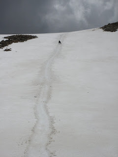
It was the first climb of the year and we were both fairly out of shape. We decided to head out for Hoosier Ridge (part of the Continental Divide), with the objective of hiking as far along it as we felt like it. We had a secondary objective of the Hoosier Ridge "summit" -- the highest bump along it, not really it's own peak.
The day began overcast with very light snow cutting visibility just a bit. The temperature was very nice though, in the high 20's, low 30s. We elected not to carry snowshoes. This was a good decision, as most of our route was either packed, ice-crusted, or windblown. We only had one annoying patch of postholing through some willows, which we corrected on the way down by following the actual trail through the trees (note for future: stay *right* at arrow that points left). As we hiked along the sun fought very hard to burn through the clouds and finally graced us with gorgeous views of the Ten Mile Range, and many past conquests: Quandary, North Star, Clinton, Traver, and McNamee, Fletcher, Helen, and Lincoln.
Deciding to quit while we were still having fun, we turned around at the bump 2.25 miles (crow flies) from the pass, still 1.5 miles (crow flies) from the "summit." We located the turn off to go up the backside of Silverheels (the avy-safe way), and maybe we'll get back to do it from that direction. We also found some great winter camping sites near treeline. I have the feeling we'll be back.
Showing posts with label winter. Show all posts
Showing posts with label winter. Show all posts
Sunday, January 17, 2010
Sunday, November 15, 2009
Attempt on Rito Alto
Dates of Trip: 12-14 November 2009
Climbers: hobo and tortoise
Location: Sangre de Cristo Range, CO, USA
Trailhead: Hermit Pass
Summit Objectives: Rito Alto
We took advantage of hobo's flying into Colorado Springs on Thursday, and the Air Force home football game on Saturday to sandwich in a drive down to the Sangres for some winter camping practice and a bit of hiking. We had both been sick with colds during the previous week, so we weren't sure how hard core the "hiking" part would be.
Our objective was to drive as far up Hermit Road, west of Westcliffe, as possible, as the jeep road theoretically goes all the way up to Hermit Pass at ~13000'. We made it to just above 9800' before the road was too slick up a steep hill (with a bit of a double fall line) to safely continue in the jeep. So we set up camp on a flat bit of snow, next to the lovely river that runs down from Hermit Lake. The night temperature was a very comfortable 36-ish degrees.
We got a good start up the jeep road in the morning, able to walk on top of the packed snow in the snowmobile tracks that covered the road. I insisted we carry my snowshoes (based on experience from Clinton/Traver/McNamee), but hobo didn't want his, so we only carried the one pair. This came in handy when we reached the spot where the snowmobiles has all turned around at the Hermit Lake Trail junction around 11,200', and soft, post-holey snow awaited us until above treeline (and even after that, in spots).
As we came to treeline at 11,800', the wind really started gusting, so we stopped at a rock-cliff shelter to gear up with long johns, balaclavas, gaiters, and goggles. As soon as we stepped out from treeline, the wind was gusting fiercely, and it only got worse as we went higher. We left the road to push straight up the hill and skip a switchback to shave off some distance, but by the time we reached 12,300', the wind had us all but stopped. It was gusting so hard that it was pushing me over. I couldn't walk when the wind was blowing, and in order to stay on my feet I had to plant my poles and duck low into the wind. We estimated that the wind was gusting up to 80 mph or so.
When the wind wasn't blowing, it was a very pleasant day! So we tried for awhile to duck and rest with the gusts and walk when it was calm. This made for really slow going as the gusts got more frequent and the calm got shorter. Since already like trying to push a brick wall up the hill, and we still had 1500' left to go (assuming the wind would only get worse [?!?] as we got higher), we decided to consider ourselves denied the summit, and enjoyed the hike down the hill and back to camp.
Back in camp, we grilled up an amazing steak dinner, and as we did, the snow started to fall. We climbed into the jeep to eat and tuned hobo'sradar detector weather radio to the National Weather Service to try and determine if we should stay the night as planned, or hightail it down the hill to avoid getting snowed in. Luckily the snow accumulation for Friday evening was forecasted to be minimal, so we chose to stay. We awoke to a winter wonderland, our tent drifted into 2 inches of dry Colorado snow. The jeep put first tracks down the only slightly sketchy road in the morning, back to civilization.
The snowstorm would actually hit in full force during the football game, and the sketchiest part of the whole expedition turned out to be driving back to Denver from the Springs on I-25 at 35 mph with about 20 feet of visibility. :oP
Climbers: hobo and tortoise
Location: Sangre de Cristo Range, CO, USA
Trailhead: Hermit Pass
Summit Objectives: Rito Alto
We took advantage of hobo's flying into Colorado Springs on Thursday, and the Air Force home football game on Saturday to sandwich in a drive down to the Sangres for some winter camping practice and a bit of hiking. We had both been sick with colds during the previous week, so we weren't sure how hard core the "hiking" part would be.
Our objective was to drive as far up Hermit Road, west of Westcliffe, as possible, as the jeep road theoretically goes all the way up to Hermit Pass at ~13000'. We made it to just above 9800' before the road was too slick up a steep hill (with a bit of a double fall line) to safely continue in the jeep. So we set up camp on a flat bit of snow, next to the lovely river that runs down from Hermit Lake. The night temperature was a very comfortable 36-ish degrees.
We got a good start up the jeep road in the morning, able to walk on top of the packed snow in the snowmobile tracks that covered the road. I insisted we carry my snowshoes (based on experience from Clinton/Traver/McNamee), but hobo didn't want his, so we only carried the one pair. This came in handy when we reached the spot where the snowmobiles has all turned around at the Hermit Lake Trail junction around 11,200', and soft, post-holey snow awaited us until above treeline (and even after that, in spots).
As we came to treeline at 11,800', the wind really started gusting, so we stopped at a rock-cliff shelter to gear up with long johns, balaclavas, gaiters, and goggles. As soon as we stepped out from treeline, the wind was gusting fiercely, and it only got worse as we went higher. We left the road to push straight up the hill and skip a switchback to shave off some distance, but by the time we reached 12,300', the wind had us all but stopped. It was gusting so hard that it was pushing me over. I couldn't walk when the wind was blowing, and in order to stay on my feet I had to plant my poles and duck low into the wind. We estimated that the wind was gusting up to 80 mph or so.
When the wind wasn't blowing, it was a very pleasant day! So we tried for awhile to duck and rest with the gusts and walk when it was calm. This made for really slow going as the gusts got more frequent and the calm got shorter. Since already like trying to push a brick wall up the hill, and we still had 1500' left to go (assuming the wind would only get worse [?!?] as we got higher), we decided to consider ourselves denied the summit, and enjoyed the hike down the hill and back to camp.
Back in camp, we grilled up an amazing steak dinner, and as we did, the snow started to fall. We climbed into the jeep to eat and tuned hobo's
The snowstorm would actually hit in full force during the football game, and the sketchiest part of the whole expedition turned out to be driving back to Denver from the Springs on I-25 at 35 mph with about 20 feet of visibility. :oP
Friday, October 16, 2009
Attempt on Clinton/Traver/McNamee
Dates of Trip: 16 October 2009
Climbers: hobo and tortoise
Location: Ten Mile Range, CO, USA
Trailhead: Wheeler Lake
Summit Objectives: Clinton, Traver, and McNamee
The trail from Montgomery Reservoir to Wheeler Lake is pretty long and relatively flat. Once you get up to the lake at 12,100', the "trail" turns sharply uphill. This would have been a workout, but not a problem, if we hadn't slogged through some moderate snow up to the lake, and then floundered through thigh-deep snow up the hill. By the time we reached the basin below the peaks at 12,500 or so, we were exhausted, wet, and perplexingly running short on daylight. Conservatively, we chose to turn back. It's possible that snowshoes would have made some difference, but it's also possible that we just plain old didn't get an early enough start.
Still, it was a beautiful day to be out in the mountains, getting some fresh air, and playing in the snow, and a good welcome to the winter climbing season.


Monday, May 25, 2009
Attempt on Pacific and Crystal
Dates of Trip: 23-24 May 2009
Climbers: hobo and tortoise
Location: Ten Mile Range, CO, USA
Trailhead: Spruce Creek
Summit Objectives: Pacific, Atlantic, Crystal, and Father Dyer
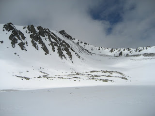
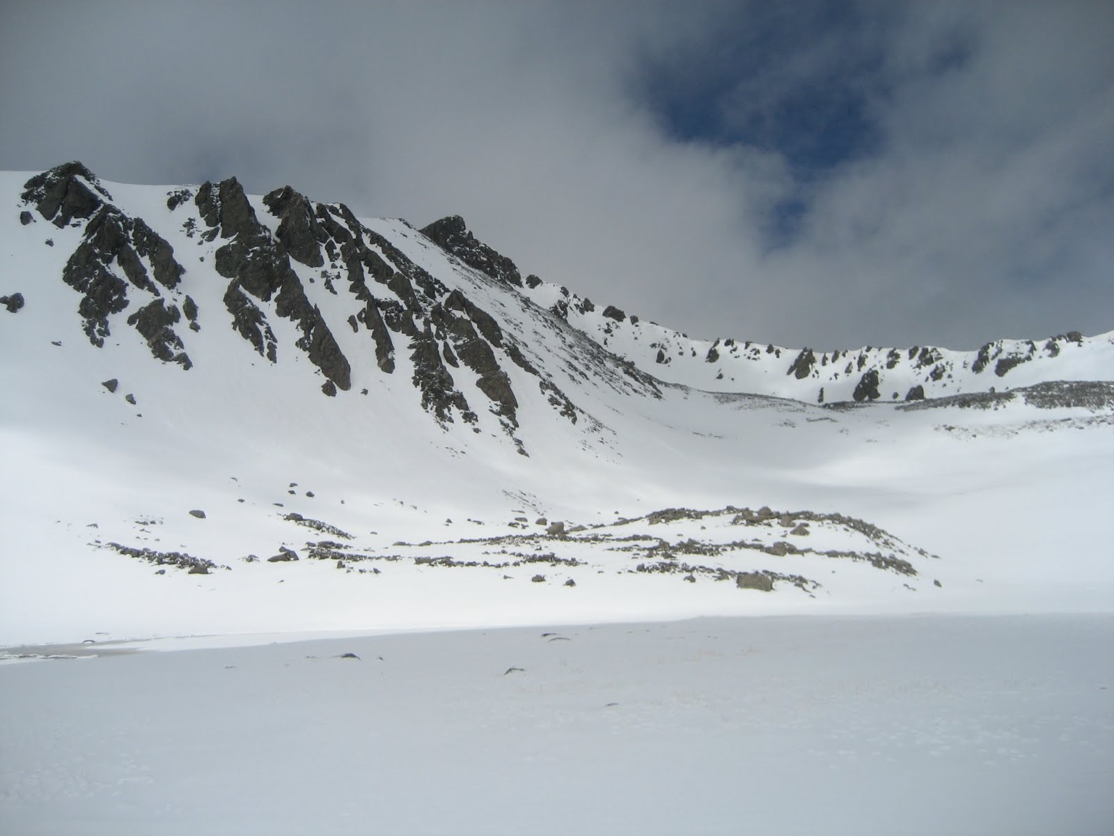
After a fabulous climb at Mt. Hope the previous week, we decided to strike out again in search of another snow climb. Pacific's Northeast face seemed a perfect opportunity for it, along with a short pack-in with easy access to several other peaks. Conditions in the Sawatch had been mostly dry with patchy snow fields to just below 12,000 ft with couloirs holding snow well up to 14,000, and we expected similar for the Ten Mile/Mosquito area. It was not so.
We made it about halfway up the 4WD road at Spruce Creek in the Jeep before being denied by snow. Additionally, the snowy road conditions induced us to bring the snowshoes, in addition to crampons and ice axes. The trail conditions were mixed up to Lower Mohawk Lake at ~11,000 - on with the snowshoes, then off again, then on, then off. We made it up the headwall to the lake, and the trail seemed snowcovered from there, so we chose to set up camp. While our homemade dehydrated cuisine soaked a bit (Curried Lamb with Couscous... yum!!), we ventured out sans packs to scope the next day's route and break trail. Hobo made it nearly fully up the next headwall to Upper Mohawk Lake and called it good.


It snowed/sleeted/rained on and off most of the night.
The next morning, it turned out that our scouting/trail breaking paid off in spades, as it was an easy push up a potentially frustrating headwall. We proceeded across vast snowfields to the base of Pacific's Northeast face at ~12,500, abandoned poles for ice axes, and began kicking steps up the face. We chose to stay with the snowshoes instead of crampons, due to the 4-6 inches of fresh powder on top from the storms the night before. We were clearly punching right through that fresh layer to the more consolidated layer beneath. We recognized that there might be some avalanche danger, but it was early and all other conditions seemed good, so we proceeded. To avoid as much danger as possible, we climbed under a rock band, instead of in the middle of the "chute."
We made it up to the rock band and stopped for a break -- it was hard work. We were about halfway up at 12,900. At that point, conditions were seeming to deteriorate. The slope got steeper. Kicking steps became much more laborious and we were driving much deeper into soft snow - not a good sign. I (tortoise), in the lead, began kicking off small rollers. As the sun came up, it was quickly warming, and the snow pack, which clearly never got a really hard freeze the night before, was only getting softer.
After some discussion we opted to turn around due to perceived avalanche danger. We flipped over and had a spectacular glissade back down to our poles. Denied Pacific (and by the connecting ridge, Atlantic), we made for Crystal (and by its connecting ridge, Father Dyer) which was to be our next day's objective. We tramped across virgin snowfields in the basin, breaking trail. We were the first hikers to venture beyond Lower Mohawk Lake in sometime, judging by the utter lack of footprints. We reached Crystal's base and began ascending by contouring the side of the basin, when it began to snow in earnest, this time with a wind behind it, even as the snow on the slopes continued to soften. Judging that the conditions were just poor, and weren't likely to improve the next day, we reluctantly turned back, deciding to pack out and get home in time for the basketball game.
When we got back to camp, the sun was out, and it was a hot 70 degrees. We laid out our wet gear to dry as much as possible while we fixed up a hot lunch of corn chili. While we were busy at camp, we heard a rumble and watched an avalanche release in a couloir on one of the nearby ridges. Seeing that only cemented the conviction that we had done the right thing in turning around, not only on Pacific, but also on Crystal.
Then, while we were eating lunch, another round of storm blew in. When it was clear that this one wasn't going to blow out again in two minutes, we scrambled to get our gear and ourselves under the (mercifully still pitched) tent. We huddled in the tent for nearly an hour while the sleet and wind buffeted us. When it finally broke, we packed up in a whirlwind and made a dash down the mountain.
Amazingly, most of the trail below the lake, including down the headwall, was nearly snow free. What a difference a day (and some rain) makes! Of course, the snow was replaced by mud, which presents its own logistical challenges (e.g. if you fall in it, it will suck), but it was a quick hour for the 2 miles back to the Jeep.
Though we failed to bag any peaks, we left convinced that this will be a great place to return, after the snow has melted out of the basin. Maybe later this summer, we'll pack in all the way up to the basin. Pacific's northeast face holds snow into August, so we may get our snow climb in yet!
Climbers: hobo and tortoise
Location: Ten Mile Range, CO, USA
Trailhead: Spruce Creek
Summit Objectives: Pacific, Atlantic, Crystal, and Father Dyer
After a fabulous climb at Mt. Hope the previous week, we decided to strike out again in search of another snow climb. Pacific's Northeast face seemed a perfect opportunity for it, along with a short pack-in with easy access to several other peaks. Conditions in the Sawatch had been mostly dry with patchy snow fields to just below 12,000 ft with couloirs holding snow well up to 14,000, and we expected similar for the Ten Mile/Mosquito area. It was not so.
We made it about halfway up the 4WD road at Spruce Creek in the Jeep before being denied by snow. Additionally, the snowy road conditions induced us to bring the snowshoes, in addition to crampons and ice axes. The trail conditions were mixed up to Lower Mohawk Lake at ~11,000 - on with the snowshoes, then off again, then on, then off. We made it up the headwall to the lake, and the trail seemed snowcovered from there, so we chose to set up camp. While our homemade dehydrated cuisine soaked a bit (Curried Lamb with Couscous... yum!!), we ventured out sans packs to scope the next day's route and break trail. Hobo made it nearly fully up the next headwall to Upper Mohawk Lake and called it good.


It snowed/sleeted/rained on and off most of the night.
The next morning, it turned out that our scouting/trail breaking paid off in spades, as it was an easy push up a potentially frustrating headwall. We proceeded across vast snowfields to the base of Pacific's Northeast face at ~12,500, abandoned poles for ice axes, and began kicking steps up the face. We chose to stay with the snowshoes instead of crampons, due to the 4-6 inches of fresh powder on top from the storms the night before. We were clearly punching right through that fresh layer to the more consolidated layer beneath. We recognized that there might be some avalanche danger, but it was early and all other conditions seemed good, so we proceeded. To avoid as much danger as possible, we climbed under a rock band, instead of in the middle of the "chute."
We made it up to the rock band and stopped for a break -- it was hard work. We were about halfway up at 12,900. At that point, conditions were seeming to deteriorate. The slope got steeper. Kicking steps became much more laborious and we were driving much deeper into soft snow - not a good sign. I (tortoise), in the lead, began kicking off small rollers. As the sun came up, it was quickly warming, and the snow pack, which clearly never got a really hard freeze the night before, was only getting softer.
After some discussion we opted to turn around due to perceived avalanche danger. We flipped over and had a spectacular glissade back down to our poles. Denied Pacific (and by the connecting ridge, Atlantic), we made for Crystal (and by its connecting ridge, Father Dyer) which was to be our next day's objective. We tramped across virgin snowfields in the basin, breaking trail. We were the first hikers to venture beyond Lower Mohawk Lake in sometime, judging by the utter lack of footprints. We reached Crystal's base and began ascending by contouring the side of the basin, when it began to snow in earnest, this time with a wind behind it, even as the snow on the slopes continued to soften. Judging that the conditions were just poor, and weren't likely to improve the next day, we reluctantly turned back, deciding to pack out and get home in time for the basketball game.
When we got back to camp, the sun was out, and it was a hot 70 degrees. We laid out our wet gear to dry as much as possible while we fixed up a hot lunch of corn chili. While we were busy at camp, we heard a rumble and watched an avalanche release in a couloir on one of the nearby ridges. Seeing that only cemented the conviction that we had done the right thing in turning around, not only on Pacific, but also on Crystal.
Then, while we were eating lunch, another round of storm blew in. When it was clear that this one wasn't going to blow out again in two minutes, we scrambled to get our gear and ourselves under the (mercifully still pitched) tent. We huddled in the tent for nearly an hour while the sleet and wind buffeted us. When it finally broke, we packed up in a whirlwind and made a dash down the mountain.
Amazingly, most of the trail below the lake, including down the headwall, was nearly snow free. What a difference a day (and some rain) makes! Of course, the snow was replaced by mud, which presents its own logistical challenges (e.g. if you fall in it, it will suck), but it was a quick hour for the 2 miles back to the Jeep.
Though we failed to bag any peaks, we left convinced that this will be a great place to return, after the snow has melted out of the basin. Maybe later this summer, we'll pack in all the way up to the basin. Pacific's northeast face holds snow into August, so we may get our snow climb in yet!
Sunday, May 17, 2009
Mt. Hope via Hopeful Couloir
Dates of Trip: 16-17 May 2009
Climbers: hobo and tortoise
Location: Sawatch Range, CO, USA
Trailhead: Willis Gulch
Summit Objectives: Hope and Quail
Summit: Hope at 13933 ft
Starting Ele: 9200 ft
Ele. Gain: 4700 ft
Distance: 10.0 mile
Packed in via the Willis Gulch TH, Little Willis Gulch trail on Saturday, 16 May. Trail was dry and hot until past the Big/Little Willis trail junction. Knee- to hip-high drifts of soft, wet, sugar snow covered the trail at times beginning around 10,600ft (around the switchbacks in the trail) and increased in frequency and annoyingness to the lake at 11,800. The final 500-700 ft is a real slog.


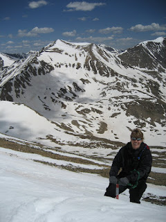
Woke at 4:45am and climbing by 5:15am. The snow above the lake was nice and solid. We donned crampons above the rock bands and began our ascent of the couloir, which had great snow in it. We could see the remnants of the avy field referenced by a previous 14ers trip report, and the snow here seemed well consolidated. There wasn't much of a cornice above Hopeful. This was my first snow climb of this level of difficulty (rated "moderate" in most places I've seen) so I had a few moments of panic at the steepness. My wonderfully patient fiance helped me readjust my crampons and get into a rhythm with my ice axe technique to feel more comfortable. We decided to exit the main couloir above the first rock band and continue up the couloir just to the climber's left (NE), which seemed a bit less steep. By the time we gained the ridge at 8:30am, the snow was softening quite a bit. hobo on the ridge (with Belford and Oxford behind? Maybe?): Image #9 We then navigated a couple of talus blocks to gain Hope?s summit. The summit block is a surprisingly gentle walk up after all it took to get there! There is still a HUGE cornice hanging off of the main summit snow pack, with some awesomely scary icicles hanging down off of it.


We descended to Hope Pass, assessing each couloir for glissade-ability. Each one seemed a little too steep with not enough run out and a little too hard-packed snow for my (overdeveloped?) sense of safety. We got to the Pass at the saddle, and the snow field from there was great for a glissade, which we took all the way down to just above the lake. We then packed up camp and packed out. We were thinking of bagging Quail next door, but we had an appointment back in town we needed to be back for, and had run out of time. It gives us a great excuse to come back to this beautiful, pristine, quiet area!

Climbers: hobo and tortoise
Location: Sawatch Range, CO, USA
Trailhead: Willis Gulch
Summit Objectives: Hope and Quail
Summit: Hope at 13933 ft
Starting Ele: 9200 ft
Ele. Gain: 4700 ft
Distance: 10.0 mile
Packed in via the Willis Gulch TH, Little Willis Gulch trail on Saturday, 16 May. Trail was dry and hot until past the Big/Little Willis trail junction. Knee- to hip-high drifts of soft, wet, sugar snow covered the trail at times beginning around 10,600ft (around the switchbacks in the trail) and increased in frequency and annoyingness to the lake at 11,800. The final 500-700 ft is a real slog.


Woke at 4:45am and climbing by 5:15am. The snow above the lake was nice and solid. We donned crampons above the rock bands and began our ascent of the couloir, which had great snow in it. We could see the remnants of the avy field referenced by a previous 14ers trip report, and the snow here seemed well consolidated. There wasn't much of a cornice above Hopeful. This was my first snow climb of this level of difficulty (rated "moderate" in most places I've seen) so I had a few moments of panic at the steepness. My wonderfully patient fiance helped me readjust my crampons and get into a rhythm with my ice axe technique to feel more comfortable. We decided to exit the main couloir above the first rock band and continue up the couloir just to the climber's left (NE), which seemed a bit less steep. By the time we gained the ridge at 8:30am, the snow was softening quite a bit. hobo on the ridge (with Belford and Oxford behind? Maybe?): Image #9 We then navigated a couple of talus blocks to gain Hope?s summit. The summit block is a surprisingly gentle walk up after all it took to get there! There is still a HUGE cornice hanging off of the main summit snow pack, with some awesomely scary icicles hanging down off of it.


We descended to Hope Pass, assessing each couloir for glissade-ability. Each one seemed a little too steep with not enough run out and a little too hard-packed snow for my (overdeveloped?) sense of safety. We got to the Pass at the saddle, and the snow field from there was great for a glissade, which we took all the way down to just above the lake. We then packed up camp and packed out. We were thinking of bagging Quail next door, but we had an appointment back in town we needed to be back for, and had run out of time. It gives us a great excuse to come back to this beautiful, pristine, quiet area!

Saturday, January 17, 2009
Mt. Helen
Dates of Trip: 17 January 2009
Climbers: hobo and tortoise
Location: Ten Mile/Mosquito Range, CO, USA
Trailhead: Spruce Creek
Summit Objectives: Helen
Summit: 13164 ft
Starting Ele: 10440 feet
Ele. Gain: 2724 feet
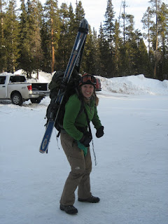
We hauled our skis up to about 11600 or so, intending to ski down most of the way. Turns out conditions weren't all that good for it above the packed road at 10,9--ish. So while I hauled my skis (and boots) halfway up the mountain, I only actually ended up using them on the packed (and mostly flat) road to the trailhead. But it was my first backcountry skiing experience. It's a start!


Climbers: hobo and tortoise
Location: Ten Mile/Mosquito Range, CO, USA
Trailhead: Spruce Creek
Summit Objectives: Helen
Summit: 13164 ft
Starting Ele: 10440 feet
Ele. Gain: 2724 feet
We hauled our skis up to about 11600 or so, intending to ski down most of the way. Turns out conditions weren't all that good for it above the packed road at 10,9--ish. So while I hauled my skis (and boots) halfway up the mountain, I only actually ended up using them on the packed (and mostly flat) road to the trailhead. But it was my first backcountry skiing experience. It's a start!


Sunday, December 7, 2008
Mt. Sniktau
Dates of Trip: 7 December 2008
Climbers: hobo and tortoise
Location: Clear Creek County, CO, USA
Trailhead: Loveland Pass
Summit: 13234 feet
Starting Ele: 11990 feet
Ele. Gain: 1244 feet
Quick trip to reacclimate to winter climbing in CO. Strong wind, typical of Loveland Pass area. Snow pack was solid and windblown, so no snowshoes needed. Steered clear of some gnarly cornices and no ice axes needed either.
Sunday, October 26, 2008
Attempt on Fletcher Mountain
Dates of Trip: 26 October 2008
Climbers: hobo and tortoise
Location: Mosquito Range, CO, USA
Trailhead: Blue Lakes
Summit Objectives: Fletcher Mountain


Climbers: hobo and tortoise
Location: Mosquito Range, CO, USA
Trailhead: Blue Lakes
Summit Objectives: Fletcher Mountain


Sunday, March 16, 2008
Welch/Dickey
Dates of Trip: 16 March 2008
Climbers: hobo and tortoise
Location: White Mountains, NH, USA
Trailhead: Welch/Dickey Loop
Summit Objectives: Welch, Dickey
Total Time: 4.0 hours
Summit: Dickey at 2734 feet, Welch at 2605 ft
Starting Ele: 1934 feet
Ele. Gain: 1800 feet
Fairly warm, humid day. Climbed in plastic boots and crampons all day. Cool granite ledges covered in ice with a little exposure. Lots of icefalls. Very fun!


Saturday, February 16, 2008
Mt. Pierce (aka Clinton)
Dates of Trip: 16 February 2008
Climbers: hobo and tortoise
Location: White Mountains, NH, USA
Trailhead: Crawford Path
Summit Objectives: Pierce
Total Time: 5.0 hours
Summit: 4310 feet
Starting Ele: 1900 feet
Ele. Gain: 2410 feet
Distance: 6.4 mile
Mt. Pierce is also known as Mt. Clinton. A beautiful day, though windy up on top - we went zero exposure. The group of kids behind us were in blue jeans. :o\ We climbed in our new plastic boots. Brought snowshoes but didn't use them -- the snow was fluffy but solid. Only ran into trouble right at tree line where we postholed up to the chest into tree wells a few times. Very fast descent. Dinner after at 99, and a cold, but comfortable night in the yurt at Intervale due to MITOC Avy School.
Sunday, June 10, 2007
Mt. Buckskin
Dates of Trip: 10 June 2007
Climbers: hobo and tortoise
Location: Ten Mile/Mosquito Range, CO, USA
Route: Kite Lake TH, Northeast slope
Summit Objectives: Buckskin
Summit: 13865 feet
Starting Ele: 3659 meter (12000 feet)
Ele. Gain: 595 meter (1950 feet)
Used ice axes, no snowshoes. Learned to GLISSADE!!


Climbers: hobo and tortoise
Location: Ten Mile/Mosquito Range, CO, USA
Route: Kite Lake TH, Northeast slope
Summit Objectives: Buckskin
Summit: 13865 feet
Starting Ele: 3659 meter (12000 feet)
Ele. Gain: 595 meter (1950 feet)
Used ice axes, no snowshoes. Learned to GLISSADE!!


Subscribe to:
Posts (Atom)