Showing posts with label stormed off. Show all posts

Saturday, September 3, 2022

Mt Bierstadt

 Date of Trip: 3 September 2022
Climbers: Travis, Clara, Trevor, and G
Location: Front Range, CO, USA
Trailhead: Guanella Pass
Summit Objective: Mt. Bierstadt
Total Time: 7.0 hours
Summit: Bierstadt at 14,065'
Ele. Gain: 2850 feet
Distance: 7.5 mile


Written by Travis

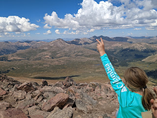
Clara and I headed back to the mountains today to climb 14er Mt. Bierstadt. This time we invited Clara's classmate and carpool buddy G and his dad Trevor. It was Clara's 4th 14er and G's first.  They were both rock stars. 

We arrived at the trailhead at 720am, and sort of amazingly were still able to park fairly close to the trailhead, albeit along the road.  We were on the trail at 730. 

We soon got to see a moose foraging among the willows.  I don't think I've ever seen a moose while climbing a 14er.  To be fair, we wouldn't have seen this one, except some other people had tracked it all morning with a telescope as it wandered from the lake, so we knew where to look.  

We then kept moving through the willows. There are boardwalks now that make it so easy. "Back in my day" finding your way through the willows was literally the crux of the route!  

The trail was packed as usual. Owing to the proximity to Denver, and its relative ease, it's one of the most climbed 14ers. We don't go for solitude.

In addition to my first moose sighting, I also saw my first supplemental oxygen use on a 14er.  You read that right.  A woman was carrying a small canister with a mouth piece as she was slogging up the trail.  I didn't see her use it, but she had it at the ready! (Another guy had one in the pocket of his pack on the way down, kind of like you would carry bear spray.) Now mind you, I just had a friend from MIT climb K2 --  the second tallest mountain in the world, literally twice as high at 28,000' -- WITHOUT SUPPLEMENTAL OXYGEN. But here we are.  

We kept going up. The kids started slowing down, so I busted out the energy chews (basically gummies for adults). That did the trick. Then we reached the summit ridge, and the Class II to the top began. It's funny how Clara can be dragging, but as soon as we transition from boring hiking to rock scrambling, she finds her next gear. "Dad, can we just do more of this?"

We summited shortly before noon, and commenced celebrating G's first 14er. And Clara's 4th (including 3 within 8 days). 

Even before making it to the top, G had declared his goal of climbing all 58 Colorado 14ers by the time he's 41. He also told us (a few times) that this was "the most wonderful thing he has ever done in his life." 

It took me back to my first time summiting a 14er (Mt Elbert, 2000).  And all the friends of mine who climbed their first 14er on a trip with me.  And how he'll probably remember this day for the rest of his life. And how at this point, that's the stuff I really care about. Me summiting this peak for the 3rd time (or is it 4?) is kind of secondary.

The weather was just about perfect, zero wind, so we hung out for nearly 30 mins. The voice in my head said you know better than this.... 

And sure enough, that voice was soon telling me "I told you so" when it started clouding up big time.  Then it was thundering. We were well on our way down by now, nearly off the eastern shoulder, mostly safe, but it was still unnerving. Clara and I started jogging down the trail. We were back in the willows as it started to rain and then pea-size hail. There was occasional lightning on the ridges around us, none too close. I'll have to add this to the list of peaks I've been stormed off (Holy Cross, Crestone Needle, maybe more)

We made it back to the van at 230pm, 7 hours after setting out. G and Trevor soon followed.


Sunday, July 18, 2010

Clinton, Traver, and McNamee

Dates of Trip: 18 July 2010
Climbers: hobo, tortoise, Karen, and Beaker
Location: Mosquito Range, CO, USA
Trailhead: Montgomery Reservoir
Summit Objectives: Clinton, Traver, and McNamee
Summits: Clinton Peak at 13857 ft, McNamee Peak at 13780 ft, Traver Peak at 13852 ft
Starting Ele: 10920 ft
Ele. Gain: 3250 ft
Distance: 10.0 mile

We had attempted this moderate day hike back in October, only to be denied by snowy slogging, and the one-two punch of a late start and short daylight.  Assuming that the snow would be now a non-issue, we decided to take advantage of aligning schedules and enjoy a day in the mountains with our friend Karen, who brought along her super-dog, Beaker.  Beaker had an extremely impressive showing, maintaining incredibly high energy throughout the expedition, and apparently not suffering from sore paws.

We made our way up to Wheeler Lake via the mostly-flat-and-very-long Platte Gulch.  After stopping for food at the lake, we began the ascent from the lower basin into the upper basin(s) ringed by the three peaks.  Slightly suspicious clouds drifted in and out of the local sky, but none seemed to do anything about it, so we continued.

Tortoise with Traver.
Tortoise and Karen taking a break.  (Beaker never really took a break.)

Tortoise and Karen ascending the talus.

Beaker waits for her master.


We all four reached the summit of Clinton, where it was warm and calm.  After requisite summit photos and summit register signings, Karen and Beaker decided to drop back down into the basin.  After assessing the weather (fine, but changeable), Hobo and I struck out on the ridge for McNamee, knowing that we could bail before Traver if necessary.  In no time at all we were on top of McNamee, which only has 80' of prominence from the connecting saddle to Clinton, so even though it's named, it technically "doesn't count." as separate.  Bah, I say to that.  On top of McNamee, we commented on how the weather had cleared up nicely, so we headed on over to Traver, (which also "doesn't count" btw - it's only 40' shy of counting, though!).

Clinton's summit.
On McNamee (2nd summit of the day).

Starting up Traver.


Traver has a blockier, crazier summit block and requires some class 2+ scrambling with just enough hairy exposure to give you some butterflies in your stomach.  We knocked that down pretty quickly, and less than an hour since leaving the Clinton summit, we stood on top of Traver.

Clinging to a boulder on Traver's summit block.
On Traver's summit with a plaque to prove it.

Looking back at Clinton from Traver


And not a moment too soon.  Sometime while we were solving the summit block, a great dark cloud had approached from the west.  After snapping our summit photo, we started to hightail it down the ridge.  We'd gotten about 2/3 of the way down from the top to the high basin when we heard the first roll of thunder.  If we hadn't been running with no regard to ankle rolling before, we sure were now.  And roll ankles we did, as well as put feet into creeks and slide uncontrollably down snowfields.  As we dropped down into the "middle" basin, it started to spit rain.  We looked up to check the look of the cloud behind us.... and there was nothing but blue sky.  The storm had passed as quickly as it had come up.

It was pretty much my wildest "getting stormed off a peak" experience to date.  I think it narrowly surpassed the thrill of California Peak, due to the fact that that time, we made it to treeline before the storm broke.

After the rush of adrenaline subsided, we picked our way back down to Wheeler Lake where we filtered some water for the walk out.  The Platte Gulch road is long, hot, and dusty.  We passed three or four 4wd vehicles grinding up the rocks, but alas, none were going down to give us a ride.

Pretty waterfall below Wheeler Lake.

A stop at the Dinky Dairy in Fairplay made my life complete on the way home.

Sunday, September 2, 2007

California Peak

Dates of Trip: 2 September 2007
Climbers: hobo and tortoise
Location: Sangre de Cristo Range, CO, USA
Route: Zapata Trail
Summit Objectives: California
Total Time: 7.0 hours
Summit: 13849 feet
Starting Ele: 3049 meter (10000 feet)
Ele. Gain: 1220 meter (4000 feet)
Distance: 13 km (8.0 mile)

Climb start at 7am, summit at 10:40am, at the car by 1:45pm. Weather was fine on the ascent, but we were watching clouds gather over Mt. Lindsey from the summit. We decided to ascend quickly, but not quite quick enough - we were off the ridge but not out of the woods before the storm started. There was small hail and a lightning threat. But all was well in the end, after a little bushwhacking. Also? Several large groups of sheep, which we ran into on both ascent and descent. Very beautiful.