Dates of Trip: 23-24 May 2009
Climbers: hobo and tortoise
Location: Ten Mile Range, CO, USA
Trailhead: Spruce Creek
Summit Objectives: Pacific, Atlantic, Crystal, and Father Dyer
After a fabulous climb at Mt. Hope the previous week, we decided to strike out again in search of another snow climb. Pacific's Northeast face seemed a perfect opportunity for it, along with a short pack-in with easy access to several other peaks. Conditions in the Sawatch had been mostly dry with patchy snow fields to just below 12,000 ft with couloirs holding snow well up to 14,000, and we expected similar for the Ten Mile/Mosquito area. It was not so.
We made it about halfway up the 4WD road at Spruce Creek in the Jeep before being denied by snow. Additionally, the snowy road conditions induced us to bring the snowshoes, in addition to crampons and ice axes. The trail conditions were mixed up to Lower Mohawk Lake at ~11,000 - on with the snowshoes, then off again, then on, then off. We made it up the headwall to the lake, and the trail seemed snowcovered from there, so we chose to set up camp. While our homemade dehydrated cuisine soaked a bit (Curried Lamb with Couscous... yum!!), we ventured out sans packs to scope the next day's route and break trail. Hobo made it nearly fully up the next headwall to Upper Mohawk Lake and called it good.
It snowed/sleeted/rained on and off most of the night.
The next morning, it turned out that our scouting/trail breaking paid off in spades, as it was an easy push up a potentially frustrating headwall. We proceeded across vast snowfields to the base of Pacific's Northeast face at ~12,500, abandoned poles for ice axes, and began kicking steps up the face. We chose to stay with the snowshoes instead of crampons, due to the 4-6 inches of fresh powder on top from the storms the night before. We were clearly punching right through that fresh layer to the more consolidated layer beneath. We recognized that there might be some avalanche danger, but it was early and all other conditions seemed good, so we proceeded. To avoid as much danger as possible, we climbed under a rock band, instead of in the middle of the "chute."
We made it up to the rock band and stopped for a break -- it was hard work. We were about halfway up at 12,900. At that point, conditions were seeming to deteriorate. The slope got steeper. Kicking steps became much more laborious and we were driving much deeper into soft snow - not a good sign. I (tortoise), in the lead, began kicking off small rollers. As the sun came up, it was quickly warming, and the snow pack, which clearly never got a really hard freeze the night before, was only getting softer.
After some discussion we opted to turn around due to perceived avalanche danger. We flipped over and had a spectacular glissade back down to our poles. Denied Pacific (and by the connecting ridge, Atlantic), we made for Crystal (and by its connecting ridge, Father Dyer) which was to be our next day's objective. We tramped across virgin snowfields in the basin, breaking trail. We were the first hikers to venture beyond Lower Mohawk Lake in sometime, judging by the utter lack of footprints. We reached Crystal's base and began ascending by contouring the side of the basin, when it began to snow in earnest, this time with a wind behind it, even as the snow on the slopes continued to soften. Judging that the conditions were just poor, and weren't likely to improve the next day, we reluctantly turned back, deciding to pack out and get home in time for the basketball game.
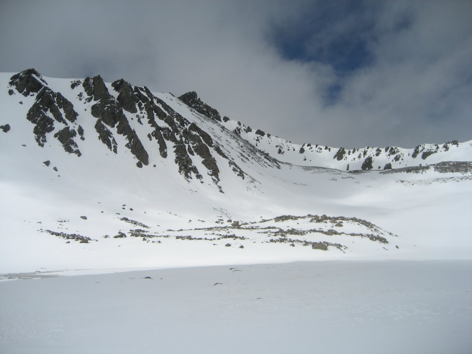
When we got back to camp, the sun was out, and it was a hot 70 degrees. We laid out our wet gear to dry as much as possible while we fixed up a hot lunch of corn chili. While we were busy at camp, we heard a rumble and watched an avalanche release in a couloir on one of the nearby ridges. Seeing that only cemented the conviction that we had done the right thing in turning around, not only on Pacific, but also on Crystal.
Then, while we were eating lunch, another round of storm blew in. When it was clear that this one wasn't going to blow out again in two minutes, we scrambled to get our gear and ourselves under the (mercifully still pitched) tent. We huddled in the tent for nearly an hour while the sleet and wind buffeted us. When it finally broke, we packed up in a whirlwind and made a dash down the mountain.
Amazingly, most of the trail below the lake, including down the headwall, was nearly snow free. What a difference a day (and some rain) makes! Of course, the snow was replaced by mud, which presents its own logistical challenges (e.g. if you fall in it, it will suck), but it was a quick hour for the 2 miles back to the Jeep.
Though we failed to bag any peaks, we left convinced that this will be a great place to return, after the snow has melted out of the basin. Maybe later this summer, we'll pack in all the way up to the basin. Pacific's northeast face holds snow into August, so we may get our snow climb in yet!
Monday, May 25, 2009
Sunday, May 17, 2009
Mt. Hope via Hopeful Couloir
Dates of Trip: 16-17 May 2009
Climbers: hobo and tortoise
Location: Sawatch Range, CO, USA
Trailhead: Willis Gulch
Summit Objectives: Hope and Quail
Summit: Hope at 13933 ft
Starting Ele: 9200 ft
Ele. Gain: 4700 ft
Distance: 10.0 mile
Packed in via the Willis Gulch TH, Little Willis Gulch trail on Saturday, 16 May. Trail was dry and hot until past the Big/Little Willis trail junction. Knee- to hip-high drifts of soft, wet, sugar snow covered the trail at times beginning around 10,600ft (around the switchbacks in the trail) and increased in frequency and annoyingness to the lake at 11,800. The final 500-700 ft is a real slog.
Woke at 4:45am and climbing by 5:15am. The snow above the lake was nice and solid. We donned crampons above the rock bands and began our ascent of the couloir, which had great snow in it. We could see the remnants of the avy field referenced by a previous 14ers trip report, and the snow here seemed well consolidated. There wasn't much of a cornice above Hopeful. This was my first snow climb of this level of difficulty (rated "moderate" in most places I've seen) so I had a few moments of panic at the steepness. My wonderfully patient fiance helped me readjust my crampons and get into a rhythm with my ice axe technique to feel more comfortable. We decided to exit the main couloir above the first rock band and continue up the couloir just to the climber's left (NE), which seemed a bit less steep. By the time we gained the ridge at 8:30am, the snow was softening quite a bit. hobo on the ridge (with Belford and Oxford behind? Maybe?): Image #9 We then navigated a couple of talus blocks to gain Hope?s summit. The summit block is a surprisingly gentle walk up after all it took to get there! There is still a HUGE cornice hanging off of the main summit snow pack, with some awesomely scary icicles hanging down off of it.
We descended to Hope Pass, assessing each couloir for glissade-ability. Each one seemed a little too steep with not enough run out and a little too hard-packed snow for my (overdeveloped?) sense of safety. We got to the Pass at the saddle, and the snow field from there was great for a glissade, which we took all the way down to just above the lake. We then packed up camp and packed out. We were thinking of bagging Quail next door, but we had an appointment back in town we needed to be back for, and had run out of time. It gives us a great excuse to come back to this beautiful, pristine, quiet area!
Climbers: hobo and tortoise
Location: Sawatch Range, CO, USA
Trailhead: Willis Gulch
Summit Objectives: Hope and Quail
Summit: Hope at 13933 ft
Starting Ele: 9200 ft
Ele. Gain: 4700 ft
Distance: 10.0 mile
Packed in via the Willis Gulch TH, Little Willis Gulch trail on Saturday, 16 May. Trail was dry and hot until past the Big/Little Willis trail junction. Knee- to hip-high drifts of soft, wet, sugar snow covered the trail at times beginning around 10,600ft (around the switchbacks in the trail) and increased in frequency and annoyingness to the lake at 11,800. The final 500-700 ft is a real slog.
Woke at 4:45am and climbing by 5:15am. The snow above the lake was nice and solid. We donned crampons above the rock bands and began our ascent of the couloir, which had great snow in it. We could see the remnants of the avy field referenced by a previous 14ers trip report, and the snow here seemed well consolidated. There wasn't much of a cornice above Hopeful. This was my first snow climb of this level of difficulty (rated "moderate" in most places I've seen) so I had a few moments of panic at the steepness. My wonderfully patient fiance helped me readjust my crampons and get into a rhythm with my ice axe technique to feel more comfortable. We decided to exit the main couloir above the first rock band and continue up the couloir just to the climber's left (NE), which seemed a bit less steep. By the time we gained the ridge at 8:30am, the snow was softening quite a bit. hobo on the ridge (with Belford and Oxford behind? Maybe?): Image #9 We then navigated a couple of talus blocks to gain Hope?s summit. The summit block is a surprisingly gentle walk up after all it took to get there! There is still a HUGE cornice hanging off of the main summit snow pack, with some awesomely scary icicles hanging down off of it.
We descended to Hope Pass, assessing each couloir for glissade-ability. Each one seemed a little too steep with not enough run out and a little too hard-packed snow for my (overdeveloped?) sense of safety. We got to the Pass at the saddle, and the snow field from there was great for a glissade, which we took all the way down to just above the lake. We then packed up camp and packed out. We were thinking of bagging Quail next door, but we had an appointment back in town we needed to be back for, and had run out of time. It gives us a great excuse to come back to this beautiful, pristine, quiet area!
Labels:
colorado,
couloir,
glissade,
pack-in,
snow climbs,
thirteeners,
winter
Saturday, January 17, 2009
Mt. Helen
Dates of Trip: 17 January 2009
Climbers: hobo and tortoise
Location: Ten Mile/Mosquito Range, CO, USA
Trailhead: Spruce Creek
Summit Objectives: Helen
Summit: 13164 ft
Starting Ele: 10440 feet
Ele. Gain: 2724 feet
We hauled our skis up to about 11600 or so, intending to ski down most of the way. Turns out conditions weren't all that good for it above the packed road at 10,9--ish. So while I hauled my skis (and boots) halfway up the mountain, I only actually ended up using them on the packed (and mostly flat) road to the trailhead. But it was my first backcountry skiing experience. It's a start!
Climbers: hobo and tortoise
Location: Ten Mile/Mosquito Range, CO, USA
Trailhead: Spruce Creek
Summit Objectives: Helen
Summit: 13164 ft
Starting Ele: 10440 feet
Ele. Gain: 2724 feet
We hauled our skis up to about 11600 or so, intending to ski down most of the way. Turns out conditions weren't all that good for it above the packed road at 10,9--ish. So while I hauled my skis (and boots) halfway up the mountain, I only actually ended up using them on the packed (and mostly flat) road to the trailhead. But it was my first backcountry skiing experience. It's a start!
Sunday, December 7, 2008
Mt. Sniktau
Dates of Trip: 7 December 2008
Climbers: hobo and tortoise
Location: Clear Creek County, CO, USA
Trailhead: Loveland Pass
Summit: 13234 feet
Starting Ele: 11990 feet
Ele. Gain: 1244 feet
Quick trip to reacclimate to winter climbing in CO. Strong wind, typical of Loveland Pass area. Snow pack was solid and windblown, so no snowshoes needed. Steered clear of some gnarly cornices and no ice axes needed either.
Climbers: hobo and tortoise
Location: Clear Creek County, CO, USA
Trailhead: Loveland Pass
Summit: 13234 feet
Starting Ele: 11990 feet
Ele. Gain: 1244 feet
Quick trip to reacclimate to winter climbing in CO. Strong wind, typical of Loveland Pass area. Snow pack was solid and windblown, so no snowshoes needed. Steered clear of some gnarly cornices and no ice axes needed either.
Sunday, October 26, 2008
Attempt on Fletcher Mountain
Dates of Trip: 26 October 2008
Climbers: hobo and tortoise
Location: Mosquito Range, CO, USA
Trailhead: Blue Lakes
Summit Objectives: Fletcher Mountain
Climbers: hobo and tortoise
Location: Mosquito Range, CO, USA
Trailhead: Blue Lakes
Summit Objectives: Fletcher Mountain
Saturday, September 6, 2008
Blanca Peak
Dates of Trip: 6-8 September 2008
Climbers: hobo and tortoise
Location: Sangre de Cristo Range, CO, USA
Trailhead: Lake Como Road
Summit Objectives: Blanca and Ellingwood
Summit: Blanca at 14345 feet
Starting Ele: 8100 feet
Ele. Gain: 6245 feet
Distance: 20.0 mile
Day 1: Arrived at Lake Como Road (worst road in Colorado!) around 330p on Saturday after picking Hobo up from COS. The Pontiac made it 2 miles up before having to be cached in a grove of pinons and prickly pears. Left the car and 8100 ft. el. at 4p. Were aiming for Lake Como (~5.0 miles, 11,700 ft el.), but lost the sun and had some fatigue going on, so stopped to pitch the tent at ~4.5 miles, 11,300 ft el.
Day 2: On the trail at 630a. Determined that even though we weren't all that far from Lake Como, we were glad we had stopped where we did the night before. Stopped at Blue Lakes to filter water. Made it over 13000ft (above the ledges, above the gully) before the sun reached us peeking over the east side ridge between Blanca and Ellingwood. All route descriptions say "difficult class 2", but I made several apparently class 3 moves on the ridge to the summit. Summitted around 11a, with a friendly group of Ohioans. Took a break on the descent in the valley with said Ohioans. Contemplated an ascent of Ellingwood, but decided against it due to lateness of hour (1p) and fatigue. Watched some others pick their way up the south face. Reached Lake Como again around 315p. Said goodbye to Ohioans and soaked feet in Lake Como. Back to camp by 530p, asleep by 8.
Day 3: Slept in til 7, packed up, and packed out - 3200ft down "worst road in Colo." At car by 1030a.
Distance and elevation are cumulative.
Climbers: hobo and tortoise
Location: Sangre de Cristo Range, CO, USA
Trailhead: Lake Como Road
Summit Objectives: Blanca and Ellingwood
Summit: Blanca at 14345 feet
Starting Ele: 8100 feet
Ele. Gain: 6245 feet
Distance: 20.0 mile
Day 1: Arrived at Lake Como Road (worst road in Colorado!) around 330p on Saturday after picking Hobo up from COS. The Pontiac made it 2 miles up before having to be cached in a grove of pinons and prickly pears. Left the car and 8100 ft. el. at 4p. Were aiming for Lake Como (~5.0 miles, 11,700 ft el.), but lost the sun and had some fatigue going on, so stopped to pitch the tent at ~4.5 miles, 11,300 ft el.
Day 2: On the trail at 630a. Determined that even though we weren't all that far from Lake Como, we were glad we had stopped where we did the night before. Stopped at Blue Lakes to filter water. Made it over 13000ft (above the ledges, above the gully) before the sun reached us peeking over the east side ridge between Blanca and Ellingwood. All route descriptions say "difficult class 2", but I made several apparently class 3 moves on the ridge to the summit. Summitted around 11a, with a friendly group of Ohioans. Took a break on the descent in the valley with said Ohioans. Contemplated an ascent of Ellingwood, but decided against it due to lateness of hour (1p) and fatigue. Watched some others pick their way up the south face. Reached Lake Como again around 315p. Said goodbye to Ohioans and soaked feet in Lake Como. Back to camp by 530p, asleep by 8.
Day 3: Slept in til 7, packed up, and packed out - 3200ft down "worst road in Colo." At car by 1030a.
Distance and elevation are cumulative.
Subscribe to:
Posts (Atom)


